May 4, 2011
Slow start to summer sea ice melt
Arctic sea ice declined slowly through most of April. Because of the slow decline in April, ice extent for the month as a whole did not approach record lows, as it did in March. However, ice extent began to decline more quickly towards the end of the month.
Central Russia saw an early retreat of snow cover, as a result of prevailing warm conditions during the past winter over the eastern Arctic and Siberia.

Figure 1. Arctic sea ice extent for April 2011 was 14.15 million square kilometers (5.46 million square miles). The magenta line shows the 1979 to 2000 median extent for that month. The black cross indicates the geographic North Pole.
Conditions in context
Ice extent declined through the month more slowly than usual, at an average rate of 29,950 square kilometers per day (11,560 square miles per day). The average daily rate of decline for 1979 to 2000 was 40,430 square kilometers (15,610 square miles) per day.
Cool conditions helped retain ice in Baffin Bay, between Canada and Greenland. Most of the ice loss during April was in the Kara Sea, north of Siberia, and the northern Baltic Sea in Europe. Ice also retreated rapidly in the western Bering Sea and the Sea of Okhotsk.
Towards the end of April, ice loss accelerated in the eastern Arctic as temperatures warmed there, leading to the formation of open water areas, or polynyas, near Franz Joseph Land and along the coast in the Kara Sea. Open water also started to form in Hudson Bay and Hudson Strait.
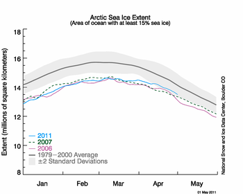
Figure 2. The graph above shows daily Arctic sea ice extent as of May 1, 2011, along with daily ice extents for previous low-ice-extent years in the month of April. Light blue indicates 2011, dashed green shows 2007, pink indicates 2006, and dark gray shows the 1979 to 2000 average. The gray area around the average line shows the two standard deviation range of the data.
April 2011 compared to past years
April 2011 continued the overall downward trend of the past thirty years, ranking fifth lowest in the satellite record. The two lowest years for April were 2007 and 2006.

Figure 3. Monthly April ice extent for 1979 to 2011 shows a decline of 2.6% per decade.
Warm temperatures for Asian Arctic; cool for northern North America
For most of April, nearly all of the eastern Arctic, north of Europe and Russia, remained warmer than average. The largest anomalies were over central Russia, northern Siberia and the Laptev and East Siberian Seas, where temperatures averaged over the month were approximately 6 degrees Celsius (11 degrees Fahrenheit) above average. In contrast, most of the western Arctic was cooler than normal, with temperatures 6 degrees Celsius (11 degrees Fahrenheit) cooler than average over Davis Strait and Baffin Bay.
The eastern Arctic remained warmer than average all winter. This suggests that that sea ice there did not thicken as much as in past winters, and may retreat rapidly as the summer melt season progresses. University of Washington's Pan-Arctic Ice Ocean Modeling and Assimilation System (PIOMAS) model of sea ice volume reflects this, showing continued very low ice mass in the Arctic compared to previous decades.
Meanwhile, the atmospheric circulation for April was characterized by a strong positive phase of the Arctic Oscillation (AO), with unusually low sea level pressure over much of the Arctic Ocean, and the lowest pressures between Greenland and Iceland. This pattern helped to draw warm air into the eastern Arctic. How this will affect observed sea ice conditions at the end of this summer remains to be seen.

igure 4. The map of air temperature anomalies for April 1 to 29, 2011 show warmer-than-normal conditions over Russia and the eastern Arctic, with coolder-than-normal conditions over North America and Greenland.
Snow cover update
Warm conditions in central Russia, linked to the positive phase of the Arctic Oscillation, promoted an early retreat of snow cover in a broad band stretching from the Urals to far eastern Siberia. However, in North America several late snowstorms led to higher-than-average monthly snow extents in the northern Plains states and western Canadian provinces. Greater-than-average snowcover was seen in the Tibetan plateau and east of the Urals.

Figure 5. This snow cover anomaly map for April 2011 shows the difference between snow cover this April, compared with average snow cover for April 1971 to 2000. Areas in orange and red indicate lower-than-usual snow cover, while regions in blue had more snow than normal.
EDIT/END
http://www.nsidc.org/arcticseaicenews/index.html