Democratic Underground Latest Greatest Lobby Journals Search Options Help Login
Google

ALERT: NEW ORLEANS, NORTH GULF REGION AND SOUTH FLORIDA

Printer-friendly format Printer-friendly format
Printer-friendly format Email this thread to a friend
Printer-friendly format Bookmark this thread
This topic is archived.
Home » Discuss » Archives » General Discussion (1/22-2007 thru 12/14/2010) Donate to DU
 
Aviation Pro Donating Member (1000+ posts) Send PM | Profile | Ignore Thu Aug-28-08 12:38 PM
Original message
ALERT: NEW ORLEANS, NORTH GULF REGION AND SOUTH FLORIDA
Edited on Thu Aug-28-08 12:41 PM by Aviation Pro
The 1100 EDT (1500Z) forecasts and analysis for TS Gustav and newly formed TS Hanna are now available on the National Hurricane Center's web site.

Gustav continues to follow essentially the same track guidance from previous forecasts. The sustained winds are just under hurricane intensity but with the storm about to enter the warmest of Carribean waters expect rapid intensification. Although it hasn't been reported yet, the IR imagery shows what appears to be convective 'hot towers' in quadrant 1 and quadrant 3, which are precursors for intensification:


Preparations should be in full earnest for an eventual landfall within 100 - 200 NM of NOLA. Using the Mariner's 1-2-3 rule and FEMA's own guidelines, a general evacuation will not be issued until the storm is 3 days or 300 NM from landfall. At this point, you have to make your own decisions with respect to evacuation.

Newly formed TS Hanna is more problematic. The storm, which would normally move into the Atlantic, is forecast to come under the influence of the high pressure system currently dominating the Florida Straits and turn toward South Florida. If the forecast holds true and given the extremely high temperature of the Gulf Stream/Florida Current, Hanna may follow the Katrina or Andrew track. Hanna may in fact turn into a 'Bahama Buster' which is how Andrew turned into a Cat 5. Residents of South Florida should monitor Hanna closely. Here is the 5-day track:

http://www.nhc.noaa.gov/storm_graphics/AT08/refresh/AL0808W5+gif/144212W_sm.gif
Printer Friendly | Permalink |  | Top
Aviation Pro Donating Member (1000+ posts) Send PM | Profile | Ignore Thu Aug-28-08 01:02 PM
Response to Original message
1. Kick for widest dissemination.....
.....
Printer Friendly | Permalink |  | Top
 
MountainLaurel Donating Member (1000+ posts) Send PM | Profile | Ignore Thu Aug-28-08 01:11 PM
Response to Original message
2. Thank you AP for these
Universities here (NO) are starting to cancel classes tomorrow and implement emergency plans, which include evacuating on-campus students and securing buildings. Same is happening at the hospital where I work: There's a pow-wow of TPTB at 4 to discuss the current track of the storm.
Printer Friendly | Permalink |  | Top
 
butterfly77 Donating Member (1000+ posts) Send PM | Profile | Ignore Thu Aug-28-08 01:26 PM
Response to Original message
3. Tell me how and why.
this could effect minnesota and the repug convention as I have heard pundits say...
Printer Friendly | Permalink |  | Top
 
Catherine Vincent Donating Member (1000+ posts) Send PM | Profile | Ignore Thu Aug-28-08 01:29 PM
Response to Original message
4. So Florida could possibly get hit with two hurricanes within days?
Good lord.
Printer Friendly | Permalink |  | Top
 
bushmeister0 Donating Member (1000+ posts) Send PM | Profile | Ignore Thu Aug-28-08 01:41 PM
Response to Original message
5. All anyone has to say is "Andrew" to get me to relive my PTSD.
Edited on Thu Aug-28-08 01:44 PM by bushmeister0
This Hannah looks very scary.

What's really dangerous is when you get a few TS's or a weak hurricane come through and you think you've dodged a bullet and then the BIG One comes through and you realize too late that the previous storms loosened things up. Trees that might have stood up suddenly come crashing down, shingles go flying etc.

When your're sitting in the candle-light listening to your roof joists creak and your ears are popping as the room glows with that eery green-yellow lightning and tranformers are blowing up every other minute, that is not the time to discover you actually didn't dodge a bullet after all.

For anyone down in South Florida who hasn't been through one of these, I can tell you from experience you should not think you can ride one of these out. Get as far away from the thing as possible. If you're lucky enough to get through the thing without losing your roof, or more, the day after will be worse.


http://www.spottedred.com/Andrew%20Photo%20Gallery.htm

No electricity, no water, no police, pitch black nights, and worst of all --- No AC. After a hurricane it gets really, really, hot and humid. More humid than you're probably used to already.

Trust me on this, if things go bad you could be fighting it out with other stinky, hot people for precious gas, food and ice -- for weeks. Better avoid the whole thing altogether.


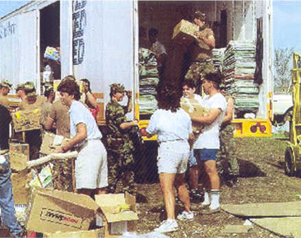
http://1-22infantry.org/history/andrew.htm

Now I have to call my parents, who lost their home in Wilma, to try and convince them not to 'ride it out' like they pledged to do last time.

Stay smart, stay safe!


Printer Friendly | Permalink |  | Top
 
Dogtown Donating Member (1000+ posts) Send PM | Profile | Ignore Thu Aug-28-08 02:12 PM
Response to Original message
6. Thanks, AP! n/t
Printer Friendly | Permalink |  | Top
 
DU AdBot (1000+ posts) Click to send private message to this author Click to view 
this author's profile Click to add 
this author to your buddy list Click to add 
this author to your Ignore list Tue Apr 30th 2024, 10:51 AM
Response to Original message
Advertisements [?]
 Top

Home » Discuss » Archives » General Discussion (1/22-2007 thru 12/14/2010) Donate to DU

Powered by DCForum+ Version 1.1 Copyright 1997-2002 DCScripts.com
Software has been extensively modified by the DU administrators


Important Notices: By participating on this discussion board, visitors agree to abide by the rules outlined on our Rules page. Messages posted on the Democratic Underground Discussion Forums are the opinions of the individuals who post them, and do not necessarily represent the opinions of Democratic Underground, LLC.

Home  |  Discussion Forums  |  Journals |  Store  |  Donate

About DU  |  Contact Us  |  Privacy Policy

Got a message for Democratic Underground? Click here to send us a message.

© 2001 - 2011 Democratic Underground, LLC