Welcome to DU!
The truly grassroots left-of-center political community where regular people, not algorithms, drive the discussions and set the standards.
Join the community:
Create a free account
Support DU (and get rid of ads!):
Become a Star Member
Latest Breaking News
General Discussion
The DU Lounge
All Forums
Issue Forums
Culture Forums
Alliance Forums
Region Forums
Support Forums
Help & Search
General Discussion
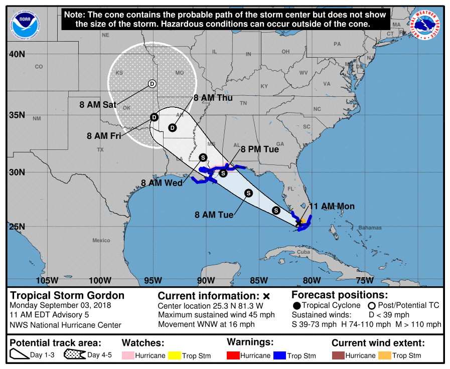
Related: Editorials & Other Articles, Issue Forums, Alliance Forums, Region ForumsTropical Storm GORDON
https://www.nhc.noaa.gov/archive/2018/al07/al072018.public.004.shtml?Tropical Storm GORDON
Tropical Storm Gordon Special Advisory Number 4
NWS National Hurricane Center Miami FL AL072018
830 AM EDT Mon Sep 03 2018
...TROPICAL STORM GORDON FORMS OVER THE UPPER FLORIDA KEYS...
...TROPICAL STORM WARNINGS ISSUED FOR PORTIONS OF SOUTH FLORIDA
AND THE FLORIDA KEYS WITH HEAVY RAINS LIKELY...
SUMMARY OF 830 AM EDT...1230 UTC...INFORMATION
----------------------------------------------
LOCATION...25.1N 80.7W
ABOUT 20 MI...30 KM W OF KEY LARGO FLORIDA
ABOUT 85 MI...135 KM SE OF MARCO ISLAND FLORIDA
MAXIMUM SUSTAINED WINDS...45 MPH...75 KM/H
PRESENT MOVEMENT...WNW OR 300 DEGREES AT 17 MPH...28 KM/H
MINIMUM CENTRAL PRESSURE...1009 MB...29.80 INCHES
WATCHES AND WARNINGS
--------------------
CHANGES WITH THIS ADVISORY:
A Tropical Storm Warning has been issued for portions of South
Florida from Golden Beach to Bonita Beach, and for the Florida
Keys from Craig Key to Ocean Reef, including Florida Bay.
SUMMARY OF WATCHES AND WARNINGS IN EFFECT:
A Storm Surge Watch is in effect for...
* Mississippi-Alabama border westward to the Mouth of the
Mississippi River
A Tropical Storm Warning is in effect for...
* Golden Beach to Bonita Beach
* Craig Key to Ocean Reef, including Florida Bay
* Alabama-Florida border westward to east of Morgan City, Louisiana,
including Lake Pontchartrain and Lake Maurepas
A Tropical Storm Warning means that tropical storm conditions are
expected somewhere within the warning areas.
For storm information specific to your area, including possible
inland watches and warnings, please monitor products issued by your
local National Weather Service forecast office.
DISCUSSION AND OUTLOOK
----------------------
At 830 AM EDT (1230 UTC), the center of Tropical Storm Gordon was
located by NOAA Doppler weather radar and surface observations
near latitude 25.1 North, longitude 80.7 West. Gordon is moving
toward the west-northwest near 17 mph (28 km/h) and a west-
northwestward to northwestward motion is expected over the next
72 hours. On the forecast track, the center of Gordon will pass
over the southern tip of the Florida peninsula this morning, move
over the southeastern Gulf of Mexico this afternoon and evening, and
reach the warning area along the central Gulf Coast by late Tuesday
or Tuesday night.
Surface observations and radar data indicate that maximum sustained
winds have increased to near 45 mph (75 km/h) with higher gusts.
Additional strengthening is forecast during the next 48 hours.
Tropical-storm-force winds extend outward up to 45 miles (75 km)
from the center.
The estimated minimum central pressure is 1009 mb (29.80 inches).
InfoView thread info, including edit history
TrashPut this thread in your Trash Can (My DU » Trash Can)
BookmarkAdd this thread to your Bookmarks (My DU » Bookmarks)
3 replies, 1174 views
ShareGet links to this post and/or share on social media
AlertAlert this post for a rule violation
PowersThere are no powers you can use on this post
EditCannot edit other people's posts
ReplyReply to this post
EditCannot edit other people's posts
Rec (2)
ReplyReply to this post
3 replies
 = new reply since forum marked as read
Highlight:
NoneDon't highlight anything
5 newestHighlight 5 most recent replies
= new reply since forum marked as read
Highlight:
NoneDon't highlight anything
5 newestHighlight 5 most recent replies
= new reply since forum marked as read
Highlight:
NoneDon't highlight anything
5 newestHighlight 5 most recent replies
Tropical Storm GORDON (Original Post)
nitpicker
Sep 2018
OP

Scurrilous
(38,687 posts)1. Looks good for So. Florida...


Ilsa
(61,690 posts)2. It's that time of year!
The warmest part of summer with warm water. Thank you for posting! Everyone stay safe.
Baclava
(12,047 posts)3. Fast mover! next stop, New Orleans