General Discussion
Related: Editorials & Other Articles, Issue Forums, Alliance Forums, Region ForumsStay safe, Malaise and head's up, Florida! I don't like the looks of TD 9.
Some of the models are showing rapid intensification into Hurricane Hermine and even though Jamaica is currently outside of the cone, a jog to the east is possible. Plus, they're predicting 4-12 inches of rain even if it misses Jamaica.
--------------------------------------------------------------
BULLETIN
Tropical Depression Nine Advisory Number 1...Corrected
NWS National Hurricane Center Miami FL AL092022
500 AM AST Fri Sep 23 2022
Corrected spelling of Colombia in rainfall statement and typo in
surf statement.
...TROPICAL DEPRESSION FORMS OVER THE CENTRAL CARIBBEAN SEA...
SUMMARY OF 500 AM AST...0900 UTC...INFORMATION
----------------------------------------------
LOCATION...13.9N 68.6W
ABOUT 615 MI...985 KM ESE OF KINGSTON JAMAICA
ABOUT 1105 MI...1780 KM ESE OF HAVANA CUBA
MAXIMUM SUSTAINED WINDS...35 MPH...55 KM/H
PRESENT MOVEMENT...WNW OR 290 DEGREES AT 13 MPH...20 KM/H
MINIMUM CENTRAL PRESSURE...1006 MB...29.71 INCHES
WATCHES AND WARNINGS
--------------------
There are no coastal watches or warnings in effect.
DISCUSSION AND OUTLOOK
----------------------
At 500 AM AST (0900 UTC), the center of Tropical Depression Nine was
located near latitude 13.9 North, longitude 68.6 West. The
depression is moving toward the west-northwest near 13 mph (20
km/h). A turn more westward is forecast over the next next day
or so followed by a turn back to the west-northwest and
northwest by this weekend.
Maximum sustained winds are near 35 mph (55 km/h) with higher gusts.
Only slow intensification is forecast over the next day or so,
followed by more significant intensification over the weekend and
early next week.
The estimated minimum central pressure is 1006 mb (29.71 inches).
HAZARDS AFFECTING LAND
----------------------
Key messages for TD Nine can be found in the Tropical Cyclone
Discussion under AWIPS header MIATCDAT4 and WMO header
WTNT44 KNHC and on the web at hurricanes.gov/text/MIATCDAT4.shtml.
RAINFALL: Tropical Depression Nine is expected to produce the
following rainfall:
Aruba, Bonaire, and Curacao: Additional 1 to 2 inches
Northern Venezuela: 2 to 5 inches
Northern Colombia: 3 to 6 inches
Jamaica: 4 to 8 inches with local maximum up to 12 inches
Cayman Islands: 4 to 8 inches
Southern Haiti and Southern Dominican Republic: 2 to 4 inches with
local maximum up to 6 inches
These rains may produce flash flooding and mudslides in areas of
higher terrain, particularly over Jamaica.
SURF: Swells generated by this system will begin affecting Jamaica,
the Cayman Islands and Cuba over the next several days. These swells
are likely to cause life-threatening surf and rip current
conditions. Please consult products from your local weather office.
 = new reply since forum marked as read
Highlight:
NoneDon't highlight anything
5 newestHighlight 5 most recent replies
= new reply since forum marked as read
Highlight:
NoneDon't highlight anything
5 newestHighlight 5 most recent replies

2naSalit
(86,502 posts)

Freddie
(9,258 posts)My son and family live in Boynton Beach, east coast about an hour north of Ft Lauderdale.

malaise
(268,846 posts)
They could get a lot of rain, or worse if it moves east.

JanMichael
(24,881 posts)Most thought it was going to hit the panhandle or Tampa and then it took a hard right turn and hit into the Charlotte harbor and hit punta Gorda and port Charlotte and places inland too.
MOMFUDSKI
(5,475 posts)like it will go up the west coast which will whoosh a ton of water onto the peninsula. Wait and see.
malaise
(268,846 posts)the only good news is that it is now moving at 14mph which lessens flooding time
Walleye
(30,996 posts)catbyte
(34,359 posts)Digital Writers
The Weather Network
Friday, September 23rd 2022, 8:11 am - Friday will be the final day for preparations as Fiona enters into Canadian waters and conditions rapidly deteriorate by Saturday morning.

The window of opportunity to prepare for Hurricane Fiona across Canada's East Coast is rapidly closing, with forecasters expecting the outer edges of Fiona to arrive in Nova Scotia and Prince Edward Island by Friday evening. Conditions will quickly deteriorate as the powerful storm approaches the region.
The storm remained a powerful Category 3 hurricane on Friday morning, with the centre of Fiona passing to the northwest of Bermuda. Some slight weakening is expected throughout the day on Friday, however Fiona is forecast to be a large and powerful post-tropical cyclone with hurricane-force winds when it approaches and moves over Canadian waters.
snip
The track of Fiona is different in terms of how historically hurricanes have moved over the East Coast, and this one is not conforming to the standard. Any time you get a unique storm like this, you're going to get big damage.
"This is different. This track is going to hook left slamming into Nova Scotia," Hamilton says. "If you look through at least recent memory in recorded history, we don't have such a left hook type of track for such a strong low pressure system."

Full story

Aviation Pro
(12,140 posts)But a Cat 2 is nothing to sneeze at.

Mysterian
(4,574 posts)Or just an optimistic guess?
Aviation Pro
(12,140 posts)The upper level winds were pushing 40 - 50 knots. That has since abated.
Mysterian
(4,574 posts)Wednesday at 2 p.m.
Tropical depression 9.
Maybe you have better info.
Aviation Pro
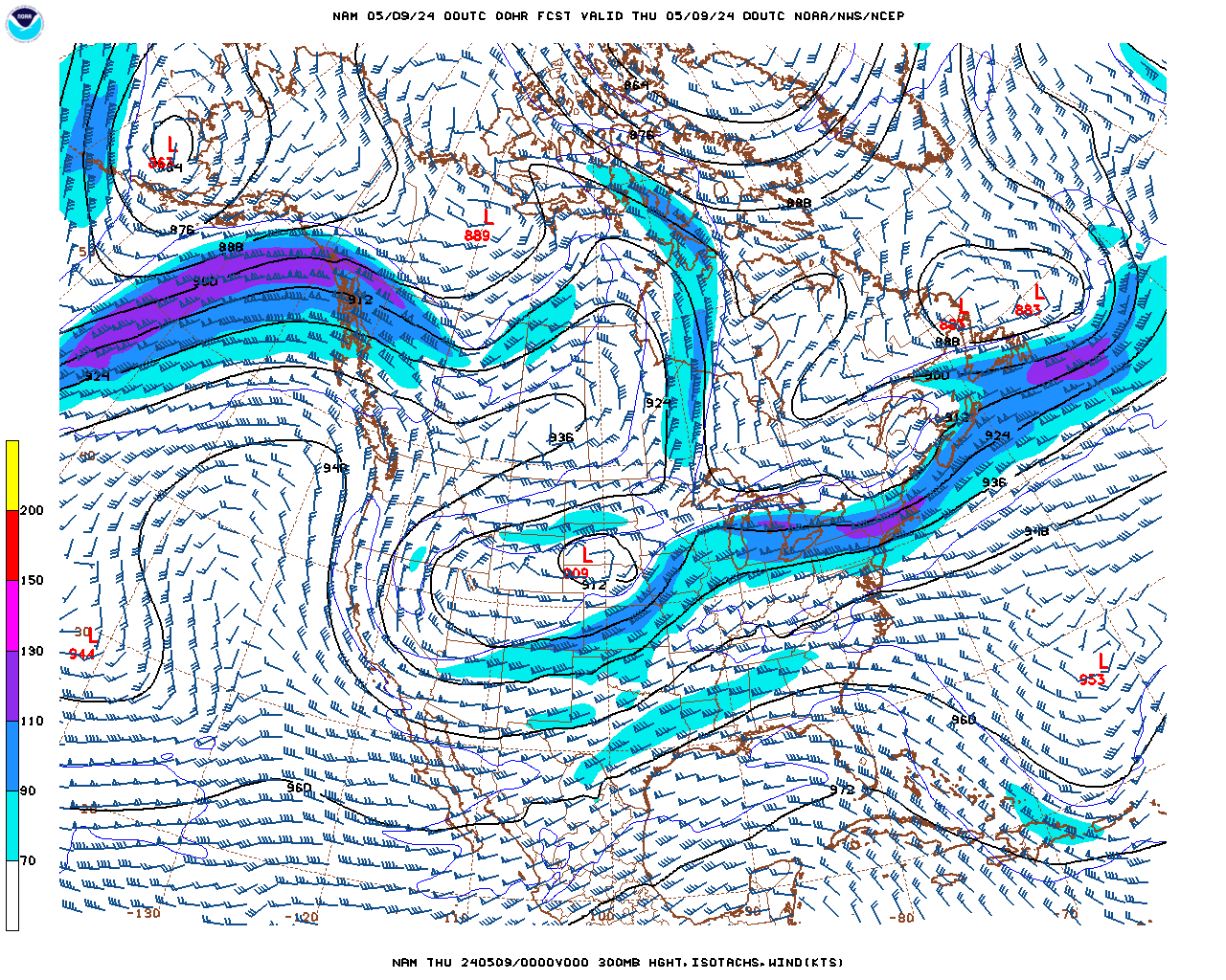
(12,140 posts)The NHC (National Hurricane Center) uses a composite methodology when it comes to cyclone forecasts. The chart I was referring to is called the 300 mb (millibar) constant pressure chart which shows, among other data, the winds aloft at about 30,000'. In the latest observation, the winds south of Cuba at this height are light (10 - 15 knots) and it gives the cyclone a chance to develop the outflow necessary for more convection. As it crosses Cuba it will encounter greater shearing forces, which may abate development somewhat before it enters the forecast area of its potential landfall on the west coast of Florida where the winds will be somewhat conducive for further development to perhaps a Cat 3.
Hope this helps, here's the chart.
Mysterian
(4,574 posts)I'll make the assumption NOAA uses the constant pressure chart, which it created, in its hurricane forecast. NOAA still shows major hurricane at 2 a.m. Wednesday, prior to landfall on the Florida coast.
Aviation Pro
(12,140 posts)NWS and NHC are the production units. Read the discussion on the NHC site and you’ll note some uncertainty in the forecast when it comes to strength. I’m not saying that it won’t be a low end Cat 3, but you need to fuse all the data and not just do a cursory glance at graphics.
Mysterian
(4,574 posts)the weather service takes all data into account when they make forecasts available to the public. Maybe someone should tell them to check the discussion board.
malaise
(268,846 posts)Thanks
Response to catbyte (Original post)
malaise This message was self-deleted by its author.

FM123
(10,053 posts)Looks like Hermine is going to bring us a LOT of rain....
catbyte
(34,359 posts)
FM123
(10,053 posts)I guess Hermine is coming our way this week. Thanks for the good wishes - we will stay safe (and as dry) as we can.
catbyte
(34,359 posts)My late husband always joked that I was a "weather psychic" because my hunches about storms were often more accurate than the National Weather Service, and I've got a bad feeling about this one. I hope I'm wrong.

allegorical oracle
(2,357 posts)without electricity five days the first time and nine days the second. Don't have a generator. Others storms have scooted past, but this one looks like it's going to encompass the whole peninsula. Can only hope it veers off east or west, or that winds have diminished a bit when it gets here. It's a real handicap to live in the northern part of the peninsula because thousands of people from S FL fill up our hotels, so there's no moving anywhere to escape except GA. Confess that I'm scared.
ironflange
(7,781 posts)Hermine has already formed, off the coast of Africa.

malaise
(268,846 posts)Ian