General Discussion
Related: Editorials & Other Articles, Issue Forums, Alliance Forums, Region ForumsHave they found the plane? Breaking on Twitter
Last edited Sun Mar 16, 2014, 03:08 PM - Edit history (1)
Sunday, March 16, 2014Did Reddit Find Malaysian Airlines Flight 370? Possible wreckage at 5°39'08.0"N 98°50'38.0"E
Users of the social network Reddit and Twitter may have found debris in the water, possibly linked to missing Malaysian Airlines Flight 370, as a Greek oil tanker steams toward the same spot after Indonesian reports of possible luggage in the water.
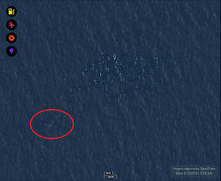
Richard Barrow has posted several images to Twitter of a satellite image that could possibly show debris from an airplane on the surface of the Ocean at coordinates 5°39'08.0"N 98°50'38.0"E, after collaborating with users of Reddit over the last 2 days.
Most interestingly, on request of the Indonesian maritime authorities, a Greek flagged oil tanker was steaming to the same location identified by the Reddit and Twitter users late Sunday evening, March 16.
The area is at the same point authorities last lost verifiable contact with MH370, as the plane headed north-west towards the Andaman and Nicobar Islands.
Below are images posted to Twitter and Reddit by several users, including Journalist Steven Daglas, from location 5°39'08.0"N 98°50'38.0"E.

http://www.bigbreakingnews.com/2014/03/did-reddit-find-malaysian-airlines.html#.UyW4L621YbA
 = new reply since forum marked as read
Highlight:
NoneDon't highlight anything
5 newestHighlight 5 most recent replies
= new reply since forum marked as read
Highlight:
NoneDon't highlight anything
5 newestHighlight 5 most recent replies

IDemo
(16,926 posts)They are a far more gifted Rorschachian than I.
B2G
(9,766 posts)
longship
(40,416 posts)You see what your brain wants to see.
AverageJoe90
(10,745 posts)I don't want to see seats, but it looks possible, sadly.

Bjorn Against
(12,041 posts)If they found the wreckage we would be hearing from the investigators not from Redditt. I am sure you cound find debris all over the ocean, but very little of it is from commercial airliners.

warrior1
(12,325 posts)IDemo
(16,926 posts)then this is a false alarm. It's been pretty well established by the satellite pings that the flight made it much further west.

petronius
(26,597 posts)phrase "breaking on Twitter" cranks my BS detector up to 11...


SidDithers
(44,228 posts)Is such a thing available?
Sid
ChisolmTrailDem
(9,463 posts)SidDithers
(44,228 posts)so you know what you can do with your "better attention"
Sid
ChisolmTrailDem
(9,463 posts)
But, go ahead, what do you suggest I do with it?
SidDithers
(44,228 posts)which would be something really new.
You gave me a site with days old images, which is most definitely not new.
Try answering the question asked, next time.
Sid
ChisolmTrailDem
(9,463 posts)satellite images, they are as "real-time" as it gets.
Experts all over the world are perusing those images. I don't see why crowd-sourcing Reddit and Twitter users should also be using them.
SidDithers
(44,228 posts)Sid
ChisolmTrailDem
(9,463 posts)Last edited Sun Mar 16, 2014, 03:41 PM - Edit history (1)
Original un-edited comment: Whatever... Go argue with a CTer. nt

ohheckyeah
(9,314 posts)not everybody stays glued to the computer, not to mention, Tomnod isn't real time images.
ChisolmTrailDem
(9,463 posts)the Reddit users were using.
The question was a nit-pick in order to start a flame-fest. So, I obliged. It's a cold, dreary Sunday and I'm bored.
ohheckyeah
(9,314 posts)it's as close to real-time as there is and post the link.
If you know whether or not the poster is glued enough and the intention was starting a flame-fest, you might be spending too much time thinking about that poster.
ChisolmTrailDem
(9,463 posts)ohheckyeah
(9,314 posts)and you're quite welcome for the comment. I'm happy to oblige.
ChisolmTrailDem
(9,463 posts)ohheckyeah
(9,314 posts)unless you were just making up crap by suggesting that it was flame bait and the poster spends plenty of time on the computer to know about Tomnod.
ChisolmTrailDem
(9,463 posts)characters and tactics.
ohheckyeah
(9,314 posts)about the poster/posters.
Have a good night.
functioning_cog
(294 posts)FYI
ChisolmTrailDem
(9,463 posts)
CreekDog
(46,192 posts)were both of them equally right in the argument we're talking about?
Iggo
(47,534 posts)That was unnecessarily ****ish.
ChisolmTrailDem
(9,463 posts)Iggo
(47,534 posts)
ChisolmTrailDem
(9,463 posts)
C'mon! We're all just killing time here! Jeez!
Bjorn Against
(12,041 posts)Google Maps does have satellite images of much of the world, although it is not exactly effective at searching for downed aircraft.
This looks like a case of someone using Google Maps, seeing something just slightly unusual and then leaping to conclusions about what it is.
SidDithers
(44,228 posts)From the dumbass answer provided above, I found out that:
http://news.msn.com/science-technology/using-crowdsourcing-to-search-for-flight-mh-370-has-both-pluses-and-minuses
It's not exactly real-time satellite images, which is what I was asking about - and which the dumbass reply provided above most certainly didn't answer - but they're current to within a few days. Good enough to try to find a plane missing for more than a week.
Sid
ChisolmTrailDem
(9,463 posts)the dumbass question above?
SidDithers
(44,228 posts)and you gave me a dumbass answer, about a website using days-old images of a very select area.
Am I going too fast for you?
Sid
Jesus Malverde
(10,274 posts)

adirondacker
(2,921 posts)


pinboy3niner
(53,339 posts)
Jesus Malverde
(10,274 posts)
B2G
(9,766 posts)Not saying it's real, but the pics are interesting enough.
SidDithers
(44,228 posts)I saw the OP and though people were able to access real-time satellite image on the web. That's something I hadn't heard of before.
The dumbass answer I was provided indicated that the crowdsourcing is being done on tomnod, which I learned is using days-old images, uploaded from DigitalGlobe, of only certain areas where the plane might be.
Thanks,
Sid
ChisolmTrailDem
(9,463 posts)
SidDithers
(44,228 posts)
Sid
ChisolmTrailDem
(9,463 posts)Before edit: "35. It's not on tonight. It's on tomorrow (Monday) night. Please pay attention. nt"

itsrobert
(14,157 posts)They repeat it on cable networks on Monday nights.
itsrobert
(14,157 posts)just kidding
ChisolmTrailDem
(9,463 posts)reflects that.
I don't ever watch FOX channel so wasn't aware of that arrangement. Thanks for the correction...
Bluenorthwest
(45,319 posts)Home of the Simpsons, not the Simpletons.
ChisolmTrailDem
(9,463 posts)Family Guy but only on other channels, like Adult Swim.
I will make an unprecedented exception tonight since I don't want to wait until tomorrow night now that I know it's on tonight, lol.

tammywammy
(26,582 posts)And you should stop being so unnecessarily rude.
http://www.cosmosontv.com
ChisolmTrailDem
(9,463 posts)I say...
Nah.
tammywammy
(26,582 posts)Your first post in this thread is rude and has only continued.
ChisolmTrailDem
(9,463 posts)SidDithers
(44,228 posts)
Dude, quit while you're behind.
Sid
ChisolmTrailDem
(9,463 posts)I edited my post to reflect that I was wrong. Everybody knows that.
And I'll decide when and where I will quit, thank you.
Response to ChisolmTrailDem (Reply #48)
itsrobert This message was self-deleted by its author.

Orrex
(63,172 posts)Typical scientific materialist.

NutmegYankee
(16,199 posts)Just small floating debris.

Barack_America
(28,876 posts)
rocktivity
(44,572 posts)Last edited Sun Mar 16, 2014, 02:36 PM - Edit history (2)
Suggesting that there was an attempt at a turnaround.
(Ciick for Map)
But considering how well the "officials" and "experts" have done thus far, who are we to cast doubt upon amateurs?

rocktivity

LeftyMom
(49,212 posts)randome
(34,845 posts)[hr][font color="blue"][center]Precision and concision. That's the game.[/center][/font][hr]
FarCenter
(19,429 posts)5.652, 98.844 is the decimal coordinates for 5°39'08.0"N 98°50'38.0"E.
I get a distance of 7 miles.
Pulau Perak, aka Silver Island, is no longer searchable by Google? But it still appears in map view if you use the above coordinates. It disappears in Google satellite view.
Very mysterious. There is an army installation and radar there.
Clearly the Malaysians would know if the plane was located there.

boston bean
(36,218 posts)B2G
(9,766 posts)itsrobert
(14,157 posts)There is a bunch of trash in the ocean. Could be anything.

HipChick
(25,485 posts)As a species we sure know how to mess up a planet..
R B Garr
(16,950 posts)It's probably all there.