General Discussion
Related: Editorials & Other Articles, Issue Forums, Alliance Forums, Region ForumsThe real size of the African continent.
I remember wondering how far the ebola outbreak in west Africa was from Tanzania where our son, whose a medical student, went on a medical mission trip this past summer. It looks like it is about as far as it is from Los Angeles to New York. In my mind I was thinking, "Ebola is in Africa. How big can Africa be? He must not be far from where the outbreak is." (Not exactly enlightened thinking, I know.) I wish I had seen this map then.

 = new reply since forum marked as read
Highlight:
NoneDon't highlight anything
5 newestHighlight 5 most recent replies
= new reply since forum marked as read
Highlight:
NoneDon't highlight anything
5 newestHighlight 5 most recent replies

joshcryer
(62,269 posts)So I knew this instinctively whenever it was pointed out. It's sort of unintuitive due to the western-centric world maps we have.
The West Wing broached this topic with how world maps are drawn:
Here's a comparison of the euro-centric (Mercator) map and an area-specific (Gall's-Peter) map:


Recursion
(56,582 posts)I like the various homolosine solutions, and I'm afraid XKCD calls me out on it:

joshcryer
(62,269 posts)You'll note that XKDC doesn't actually say why they hate it. Except it's probably just damn ugly compared to everything else. Because we're used to Mercator. In the end, the 2D area projection is probably best. And like West Wing argued, flip it upside down, if you really want to be non-centric toward western countries.
If it's bothersome, switch the N-S poles on compasses (after all, N points to S and S points to north!). 
Recursion
(56,582 posts)Only the homolosine solutions can avoid that.

DebJ
(7,699 posts)basic geography / what maps are for, and you saved me from looking this up.
Using the Peter's map 'upside-down' shows the very small percentage of land area that dominates the world.
Once again.
joshcryer
(62,269 posts)Have 'em measure out the various continents with a fabric ruler. Should be a fun exercise.
DebJ
(7,699 posts)that easily sits on the desk for a quick reference. The other is a much older, regular size globe that my Dad had. But his Mom and Dad are tidy freaks and they wouldn't allow such a thing to sit around the house, which must look like a Home and Gardens layout at all times. I'm buying him a big storage box to put all the geography stuff in, so we can retrieve it when I visit. Or he can retrieve it when HE wants to. I did the same with space stuff and bug stuff; seems to be a system that accomodates my daughter's system of things, and of his own initiative during play times, he will retrieve the boxes and go through everything. He's become pretty sharp at naming the planets and identifying their pictures. I woke up one morning during one of my overnight visits to find him sitting on my bed with all the space stuff from the box, talking to himself about each of the planets. My husband made him a little moonscape by sculpting and painting blueboard and we gave him little astronauts and shuttles. All this done when he looked at the moon at the age of 3, and said, "It's too far to ever go there".
I signed him up for a program called Little Passports, where you 'visit' a new country each month (but since he is four and I only see him once a month, we will go more slowly). I'm adding lots of stuff to what they send out.... for example, the first country is Brazil. He loves soccer and plays it, so I bought him a young chidlren's book on Pele, as a child. And of course one on the wonders of the Amazon region. And I'm finding clips of music and other cultural pieces for each country. Hopefully somewhere in the mix of these various things from each country, something will appeal to him and 'stick' so he gets a better and early grasp. He loves puzzles, so I bought him a floor size map of the continents, with pictures of animals, ships, planes, etc on it. He can do it in no time flat. He can now also point out where he lives, where his other grandparents were born (Latvia), where they live now (other side of the continent from us),and where his Dad's brother lives (Denver). He's now learning the names of the continents (though he can't yet read). It's really fun. For both of us.

hobbit709
(41,694 posts)40% of the people couldn't properly place the United States on an outline map of the continents.
Xilantro
(41 posts)Scuba
(53,475 posts)

African oil takes growing importance, mainly after the 2003 oil crisis and recent oil reserves discoveries. Sudan and Nigeria are two of the main oil producers. China owns 40% of Sudan's oil production. Oil is provided by both continental and offshore productions. Sudan's oil exports in 2010 are estimated by the United States Department of State at $9 billion with United States dollars.
Five countries dominate Africa's upstream oil production. Together they account for 85% of the continent's oil production and are, in order of decreasing output, Nigeria, Libya, Algeria, Egypt and Angola. Other oil producing countries are Gabon, Congo, Cameroon, Tunisia, Equatorial Guinea, the Democratic Republic of the Congo and Côte d'Ivoire. Exploration is taking place in a number of other countries that aim to increase their output or become first time producers. Included in this list are Chad, Sudan, Namibia, South Africa and Madagascar while Mozambique and Tanzania are potential oil producers.
http://en.wikipedia.org/wiki/Natural_resources_of_Africa

littlemissmartypants
(22,628 posts)The billionaire oil-igarchs (sic) don't want anyone to know of the immense and beautiful land they have yet to exploit and destroy.

logosoco
(3,208 posts)the Peace Corps. He left this past July. We also spent a lot of time with the globe to show our grandsons where there uncle will be.
I always tried to have a good perspective of where places are on this planet, but having a family member move to another country changes the way you look at the world!
I was not too worried about ebola because I knew the PC evacuated the volunteers that were near the outbreak. But I do still worry about the folks there.
I am worried now about the Boko Harem extremists. I know the medical community is working on things like Ebola, but that seems more like science, whereas things like terrorism are not. Geography seems easy to learn about compared to people!
Recursion
(56,582 posts)This version (which I think comes from Hobo-Dyer) also has problems. Ultimately you can't "accurately" place any significantly large part of the earth on a flat image without distortion.
joshcryer
(62,269 posts)Though I said this to you earlier.
I don't think any other metric applies, because visually, we see landmass. Therefore, if we are to look at landmasses, then we must recognize which ones are the largest.
Recursion
(56,582 posts)And you can accurately measure latitude but not longitude -- you need a map that is equidistant north/south, and you don't really care what it looks like east/west. Actually my favorite homolosine projection puts the interruptions inside land masses and flatly projects the oceans...

Bosonic
(3,746 posts)
Marthe48
(16,927 posts)be sure to ask which part of Africa they are from, and then what country. I knew a student from Ghana and she was insulted when anyone said she was from Africa. It is a big continent and there are many,many nations existing on it.

ChazII
(6,204 posts)If they would check to see how many miles an inch equaled that would help, too. Your map is a good visual to help folks 'see' just how big Africa is. Thanks for sharing.

NewJeffCT
(56,828 posts)the map with Africa is the entire continent of Africa. Other than most of Europe, they are putting countries inside of Africa, not continents. Asia as a continent is 50% larger than Africa, which is about 20% larger than North America.

CTyankee
(63,900 posts)continental U.S. Interesting!

Fred Sanders
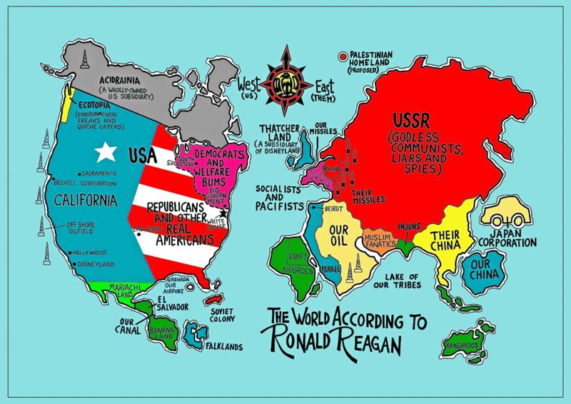
(23,946 posts)Africa and the world as seen by President Ronald Reagan: