People trapped, 2.5M without power as Ian drenches Florida
Source: AP
By CURT ANDERSON
ST. PETERSBURG, Fla. (AP) — Hurricane Ian left a path of destruction in southwest Florida, trapping people in flooded homes, damaging the roof of a hospital intensive care unit and knocking out power to 2.5 million people before aiming for the Atlantic Coast on Thursday.
One of the strongest hurricanes to ever hit the United States churned across the Florida peninsula, threatening catastrophic flooding inland. Ian’s tropical-storm-force winds extended outward up to 415 miles (665 km), and nearly the entire state was getting drenched.
The National Hurricane Center said Ian became a tropical storm over land early Thursday and was expected to regain near-hurricane strength after emerging over Atlantic waters near the Kennedy Space Center later in the day. Flooding rains continued across the state, and a stretch of the Gulf Coast remained inundated by ocean water, pushed ashore by the massive storm.
“Severe and life-threatening storm surge inundation of 8 to 10 feet above ground level along with destructive waves is ongoing along the southwest Florida coastline from Englewood to Bonita Beach, including Charlotte Harbor,” the center said.
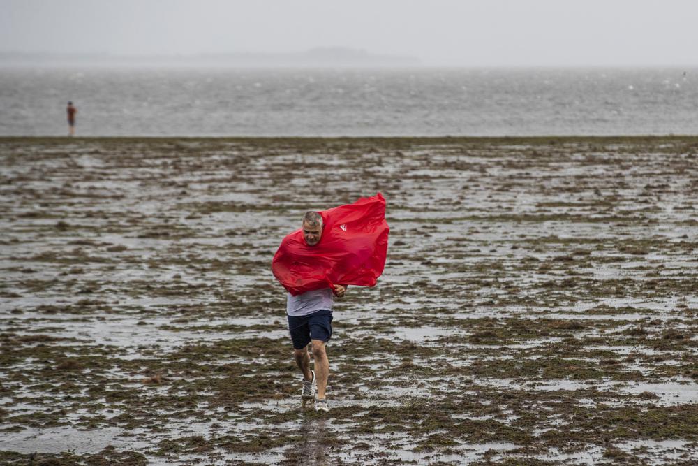
Curious sightseers walk in the receding waters of Tampa Bay due to the low tide and tremendous winds from Hurricane Ian in Tampa, Fla., Wednesday, Sept. 28, 2022. (Willie J. Allen Jr./Orlando Sentinel via AP)
Read more: https://apnews.com/article/floods-hurricanes-florida-united-states-storms-d4db93bcac5af1134e31a3b7f2f694f0?utm_source=homepage&utm_medium=TopNews&utm_campaign=position_01
 = new reply since forum marked as read
Highlight:
NoneDon't highlight anything
5 newestHighlight 5 most recent replies
= new reply since forum marked as read
Highlight:
NoneDon't highlight anything
5 newestHighlight 5 most recent replies

bucolic_frolic
(43,128 posts)
Bengus81
(6,931 posts)So there should be no investigation.

eallen
(2,953 posts)Bengus81
(6,931 posts)"One flight took off from San Antonio and made a stop in Florida and South Carolina before landing in Martha's Vineyard. The second flight also stopped in Florida, but made another stop in Charlotte, North Carolina, before landing in Martha's Vineyard."
bedazzled
(1,761 posts)That us even worse Wonderful! Wonder why no one is mentioning it.
Bengus81
(6,931 posts)I read it somewhere or it was reported on TV on day 1.
bedazzled
(1,761 posts)I guess only one of the flights did that but I think it is most important

BumRushDaShow
(128,856 posts)Michael hit the Mexico Beach/Panama City FL area in 2018 with ~155+ mph winds (like Ian) and featured many feet of surge along the coast. It stripped and snapped the trees by the Tyndall Air Force base nearby and somewhat inland from the coast, and that had catastrophic damage ,and is currently deactivated.
I always liked this animated depiction of possible damage based on wind speeds, which will obviously vary from storm to storm, but will give some kind of visual idea of what could happen -

BigmanPigman
(51,584 posts)BumRushDaShow
(128,856 posts)when you see this kind of damage to something like trees which is what Hurricane Michael did in the below pics, it screams "Cat 5" although it was originally registered as a Cat 4 at landfall (where NOAA finally upgraded Michael to Cat 5 at landfall, months later).
That storm actually had sustained winds of 160 mph, but because an anemometer broke at the AFB there due to the extreme/violent gusts from the hurricane, they didn't have a good confirmation source at the landfall spots, of what the winds really were. But the damage was unmistakable.
HURRICANE MICHAEL PICS (2018)

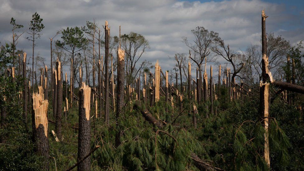

The hope is that they can get a good evaluation of Ian at landfall because a bunch of us were monitoring the recon flights into the storm and there were a number of dropsonde readings that were showing in excess of the 155+ winds/wind gusts (including one that I think may have even been unflagged, of 170 mph), where 157 mph and higher "sustained" would be Cat 5 vs Cat 4. The key would be "sustained" in order to make a good call as well.
BigmanPigman
(51,584 posts)To me anyway.
I believe that the global weather experts will need to adjust the current weather classifications with current weather info.
BumRushDaShow
(128,856 posts)to check on some folks, bring supplies/chainsaws and drive around and it looks pretty bad. Just the route south from where they were previously down I-75, they ran into a huge backup (there was also a utility convoy headed down with bucket trucks) and the backup was because police took 3 lanes down to 1 to go under an overpass that collapsed on the right side (apparently had been flooded) that was being manually propped up so that cars/trucks in the far left lane could go under it. 
Closer to Ft. Meyer's Beach they have been on a road that is littered with boats that were torn out of their moorings and are pushed up against the guard rails.

RussBLib
(9,006 posts)...which reminds me, we live on a barrier island in TX, connected to the mainland by a single Causeway. Do they have ferries here and there in Florida large enough to transport vehicles?
We don't. Closest ferry here is 300 miles away.
Oh, the anxiety. Push it down.....
Dysfunctional
(452 posts)
AKwannabe
(5,651 posts)Nor should cities be built below sea level for crying out loud!!!!

wnylib
(21,432 posts)Tap/click on the arrows to go through the photos.
https://www.google.com/amp/story/s/www.washingtonpost.com/photography/interactive/2022/photos-hurricane-ian-florida/