Pennsylvania
Related: About this forumBREAKING: PA Supreme Court issues new map
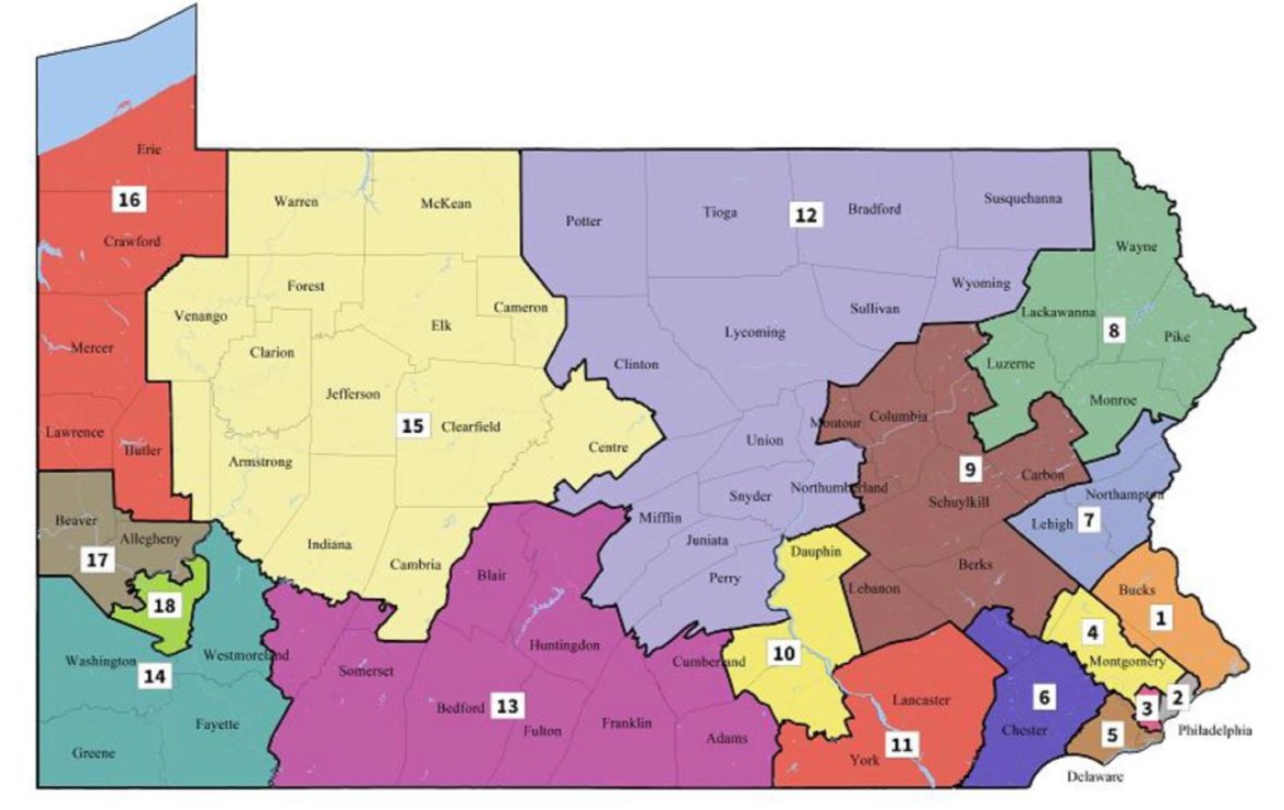
http://www.philly.com/philly/news/politics/pennsylvania-gerrymandering-supreme-court-map-congressional-districts-2018-elections-20180219.htmlEdit to add - the court completely re-numbered the districts! Also edit to add the proposed new map (thanks to DeminPennswoods
 ) -
) -
 = new reply since forum marked as read
Highlight:
NoneDon't highlight anything
5 newestHighlight 5 most recent replies
= new reply since forum marked as read
Highlight:
NoneDon't highlight anything
5 newestHighlight 5 most recent replies

DeminPennswoods
(15,265 posts)
BumRushDaShow
(128,527 posts)Was about to update and you saved me the trouble! 
DeminPennswoods
(15,265 posts)You beat me to that! 
DeminPennswoods
(15,265 posts)nt

Gothmog
(144,945 posts)
MyOwnPeace
(16,920 posts)I got moved from one Red-Neck district to another! 
I am their "token" Democrat!

femmocrat
(28,394 posts)We would be in the new 14th. Wish they hadn't split Westmoreland Co. though. We have been fractured for such a long time. I don't see much in the way of democratic strongholds in the 14th. Looks as red as before.
DeminPennswoods
(15,265 posts)in the new 16, 17, 6 and 10 at least.
BumRushDaShow
(128,527 posts)have majority Democratic party registration per this - http://www.dos.pa.gov/VotingElections/CandidatesCommittees/RunningforOffice/Documents/2017%20Election%20VR%20Stats.pdf (PDF)
That doesn't mean they have voted that way recently, however the way it was before, as a PA-9 & PA-18, you had more R blendage in there in terms of voter registration stats. The issue there is for Dems to either shit or get off the pot. They seem to vote (D) for local but not national.
Yo_Mama_Been_Loggin
(107,766 posts)BumRushDaShow
(128,527 posts)Problem is that the GOP did not comply with the PA Supreme Court order and the SCOTUS already refused to hear their previous challenge noting that this was a PA state Constitution issue ("states rights" ) not a federal one. They were given ample opportunity to call the legislature into brief session to even create a "shell bill" that could have included the map they eventually submitted, but they didn't. Nor did the map they submitted at the last minute, have any legislative input or review at all.
So they petulantly slow-walked their response and manufactured a means to try to halt this in the federal courts, but they would have to find some U.S. Constitutional reason to do so.
So we will see...
BumRushDaShow
(128,527 posts)One tweet -
Link to tweet
TEXT
Brian Amos @BrianAmos
2016 presidential results for the new remedial PA map. 10R-8D, but with a decent number of competitive districts.

Brian Amos @BrianAmos
Here's the rest of the 2016 statewides. Third parties excluded from these calculations for comparison.

3:28 PM - Feb 19, 2018

FakeNoose
(32,599 posts)Unfortunately Jill Stein's 3rd party votes became a major factor in 2016, as we watched Hillary Clinton lose the election even though she won the popluar vote. I believe that ignoring 3rd parties/independents is an error that the Democratic Party regularly makes.
However that being said, this new map is a big step towards ending Satan's gerrymandering in Pennsylvania!
We must remain vigilant for any crap the Trussian Repukes try to pull - they'll do anything to cheat and game the system.


BumRushDaShow
(128,527 posts)3rd parties never got the kind of vote that we saw happen in 2016. E.g., here in Philly, combined 3rd party votes were ~4,000 - 5,000 out of something like 650,000+ total. Yet in 2016, Both Stein and Johnson tripled their 2012 votes, with a total > 15,000.
So the question might be, was 2016 a one-off or is this about to become "the norm" (with Russian interference, etc)?
BumRushDaShow
(128,527 posts)February 19th, 2018, 3:20pm by Sam Wang

Here’s the new Congressional map for Pennsylvania, drawn by the special master. It splits 13 counties, less than any plan offered to the court. The only plan that splits fewer counties is the “compact D gerrymander” that the Princeton Gerrymandering Project posted over the weekend. Our plan scores comparably to or better than the special master’s plan on the metrics the court set out (fewer county and municipality splits, performs just as well on compactness metrics).
As we showed over the weekend, it is just possible within the Pennsylvania Supreme Court’s rules to allow a plan that reaches partisan balance, i.e. a 9 D, 9 R outcome for a 50-50 statewide vote. However, those rules bias the range of possibilities in favor of Republicans, so that a Republican gerrymander – one of the proposals on the table – was also a possibility.
It appears as if the special master was trying to achieve partisan balance (as opposed to, say, picking a plan that was in the middle of the range of possible maps). His map – and the one we gave over the weekend – show that even under the constraint of compactness and not splitting political jurisdictions, it is still possible to undo the effects of population clustering. Notably, he did so while keeping most population centers together.
It now seems clear that the Pennsylvania GOP made a serious tactical error. The governor and Democratic legislators had offered a plan that would have retained some GOP advantage. The new plan erases that advantage entirely. In our analysis, based on the 2016 vote the new map produces 5 Democratic districts, 7 Republican districts, and 6 tossup districts. The maximum likely performance by Democrats in 2018 would be 11 seats, a gain of 6 seats over their current representation. That gain would be one-fourth of the 24 seats they need to win control of the House of Representatives. Of course, some of those gains could also go away in a later year that was good for Republicans. That’s the point of electoral competition.
http://election.princeton.edu/2018/02/19/introducing-the-new-pennsylvania-congressional-map/
DeminPennswoods
(15,265 posts)as to Dem districts 6 vs 5 and 8 vs 6 toss ups. 
BumRushDaShow
(128,527 posts)when they drew what became the 2011 map, they carved districts around and through smaller cities like Chester and Reading and Harrisburg and Easton, and then swung the districts where they put those cities, to far flung nether lands of the state in order to capture rural votes, tilting the final district makeup to (R). The ridiculous PA-7 reached the point of extremes in doing that. And having the current PA-10 start in Central PA and end by wrapping around the NE corner of the state, is another example.
When you return those cities geographically to their surrounding areas, the whole dynamic changes.
And as a note on Sam's map. The one bright area on the east-central side of the state that was not identified, appears to be Allentown, Bethlehem, & Easton (Lehigh Valley) and the other SE of Harrisburg is probably Lancaster.
DeminPennswoods
(15,265 posts)The bright dot in the exact center of the state is Univ Park/State College.
The "tail" going northwest out of Pgh is the 376/Parkway corridor (Robinson Twp, Montour, Moon, etc).
The two bright dots to the SE of Pgh should be Johnstown and Altoona.
BumRushDaShow
(128,527 posts) DeminPennswoods
(15,265 posts)see just a few dim lights. Sort of like seeing those pictures from space of North and South Korea at night.
BumRushDaShow
(128,527 posts)until you mentioned it.  I assumed "lights from space" but it's population dots on a black background.
Hopefully this will underscore to people (including DUers) that although it looks severe when you color the state "red" in large swaths of land and "blue" around the state border urban areas, those large red swaths are literally EMPTY of people. From one of the stats that I found, I think it was 36 of the 67 PA counties that have less than 100,000 people each and 3 of those 36 have <10,000 total.
DeminPennswoods
(15,265 posts)That's part of why it's so lightly populated. Then you have Allegheney Mtns running through Johnstown, Altoona, State College via Rt 22, the mid-state southern border counties and the Pocono Mtns in the NE part of the state.
BumRushDaShow
(128,527 posts)and that is Fairmount Park!
DeminPennswoods
(15,265 posts)around the tunnels by exiting at Ft Littleton (old exit 13 or 14), then getting back on the pike farther down. I pulled out one my PA state maps to look for what alternate roads there might be once we exited. I think there were about two roads besides the tpk. We went up and down 2 lane roads over the mountains until we were able to re-enter the tpk. There was just nothing around! I was glad it was during the day and not at night.
BumRushDaShow
(128,527 posts)The car's navigation system sortof took us a back way through the hills and dale and covered bridges around Kutztown. 
DeminPennswoods
(15,265 posts)with the GOP argument that the Court ruling makes it so hard for people to know what district they are in.
This despite there being a whopping 4 counties split into different districts with only Butler being split 3 ways owing to Cranberry, which abuts New Sewickley/Freedom in Beaver County being in the new 17th. Otherwise every other county is completely contained in a new CD.
It's pretty easy to look at the map and figure out what your new district is.
DeminPennswoods
(15,265 posts)Here are some links to court cases filed against the 2010 map:
PA Supreme Court Order 1/24/2012: http://redistricting.lls.edu/files/PA%20holt%2020120125%20order.pdf
Majority Opinion: http://www.pacourts.us/assets/opinions/Supreme/out/j-2-12_31-2012mo.pdf#search=%22amanda%20holt%22
Amanda Holt (lead case after consolidation above): http://amandae.com/
All redistricting cases against 2010 map: http://redistricting.lls.edu/cases-PA.php#PA