Israel/Palestine
Related: About this forumThe [Green] Line is long gone: Gilo to be expanded, creating annexable bloc that includes Cremisan
Full title: “The [Green] Line is long gone”: Gilo to be expanded, creating annexable bloc that includes Cremisan Valley and extends to Har Gilo
Published:
5 Jan 2016
On Wednesday 16 December 2015, a plan to construct 891 residential units on the slopes south of the neighborhood of Gilo was authorized by Jerusalem’s Local Planning Committee to be deposited for review. Gilo is located on West Bank land that Israel annexed unilaterally to Jerusalem and still constitutes occupied territory. Therefore, under international law, Gilo’s status is no different than those of any other Israeli settlement in the West Bank. The broader urban building plan was approved by the Jerusalem Regional Planning Committee in December 2012. However, as the land slated for construction is split among multiple owners – including the Israel Land Authority, the Jewish National Fund, and the private “Gilu Beilo” company, to name a few - the Local Planning Committee had to give its seal of approval for unifying and re-parceling the various plots to enable construction.
The committee was scheduled to review the reorganization plan in November 2015, but discussion was postponed at the last minute to avoid a diplomatic incident during PM Benjamin Netanyahu’s visit to Washington. In December the committee approved the unifying and re-parceling plan, thereby allowing the construction plan to be deposited for review.
The plan is one of three the District Committee approved for Gilo in 2012. A second plan, similar in scope, is set to expand the settlement west towards the Palestinian village of al-Walajah. Israel has already expropriated half of al-Walajah’s land, confiscating some for the original construction of Gilo and seizing other parts by military order to establish the settlement of Har Gilo. In addition, the Separation Barrier cuts off al-Walajah residents from their farmed land - some of which was declared Refa’im Stream National Park, whose area abuts the present plan - and entirely prevents any possible development of the village. The third plan will enable construction of about hundred residential units close to the Palestinian neighborhood of Beit Safafa. Unlike the first plan, the other two plans apply to territory that Israel has declared “state land” – a procedure based on a skewed legal interpretation aimed at transferring Palestinian-owned land to settlements. State land status obviates the need for approval to unify and re-divide the land before the plans can be deposited for review. With regard to the plan that will expand Gilo toward al-Walajah, tenders have already been issued for building the residential units and contractors are expected to receive orders approving construction in the coming weeks.
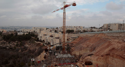
Construction work for expansion of Gilo in 2011. Photo by Baz Ratner, Reuthers, 16 Jan. 2011
According to Jerusalem Municipality figures, 32,000 people lived in Gilo in about 9,000 residential units. The three plans detailed above would increase the number of approved residential units in Gilo by 23.5 percent.
http://www.btselem.org/jerusalem/20150105_expansion_of_gilo_settlement