Different track from Danielle
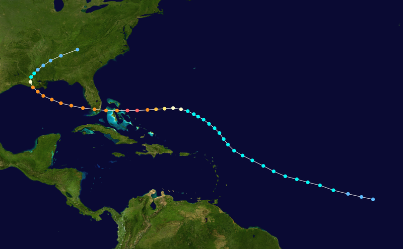
On the basis of a Dvorak T-number of 2.0, it is estimated Tropical Depression Three developed late on August 16 about 1,630 miles (2,620 km) east-southeast of Barbados.<1>
Embedded within the deep easterlies, the depression tracked west northwestward at 20 miles per hour (32 km/h).<8> Initially, moderate wind shear prevented strengthening, though a decrease in shear allowed the depression to intensify into Tropical Storm Andrew at around 1200 UTC on August 17.<1> By early on August 18, the storm maintained concentrated convection near the center with spiral bands to its west as the winds increased to 50 miles per hour (80 km/h).<9> Shortly thereafter the thunderstorms decreased markedly during the diurnal minimum,<10> and as the storm turned to the northwest increased southwesterly wind shear from an upper-level low prevented Andrew from maintaining deep convection.<1> On August 19, a Hurricane Hunters flight into the storm failed to locate a well-defined center,<11> and the next day a flight found that the cyclone had degenerated to the extent that only a diffuse low-level circulation center remained; observations indicated the pressure rose to an unusually high 1015 mbar. The flight indicated Andrew maintained a vigorous circulation aloft, with winds of 80 miles per hour (130 km/h) recorded at flight level. Subsequently, the upper-level low weakened and split into a trough, which decreased the wind shear over the storm. Simultaneously, a strong high pressure cell developed over the southeastern United States, which built eastward and caused Andrew to turn to the west.<1> Convection became more organized as upper-level outflow became better established.<12> An eye formed, and Andrew attained hurricane status early on August 22 while located about 650 miles (1,050 km) east-southeast of Nassau, Bahamas.<1>
Six hours after becoming a hurricane, Andrew was predicted to make landfall near Jupiter, Florida with winds of 105 miles per hour (169 km/h).<13> The hurricane accelerated as it tracked due westward into an area of very favorable conditions, and late on August 22 began rapidly intensifying; in a 24 hour period the pressure dropped 47 mbar to a minimum pressure of 922 mbar.<1> On August 23 the cyclone attained Category 5 status on the Saffir-Simpson Hurricane Scale, and at 1800 UTC Hurricane Andrew reached peak winds of 175 miles per hour (282 km/h) while located a short distance off Eleuthera island in the Bahamas.<14> Operationally, the National Hurricane Center assessed its peak intensity as 150 miles per hour (240 km/h),<15> which was upgraded to 155 miles per hour (249 km/h) in post-analysis; the hurricane was re-classified as a Category 5 hurricane twelve years subsequent to the hurricane.<14> A small tropical cyclone, winds of 35 miles per hour (56 km/h) extended out only about 90 miles (140 km) from its center.<16> Subsequent to peaking in intensity, the hurricane underwent an eyewall replacement cycle,<17> and at 2100 UTC on August 23, Hurricane Andrew struck Eleuthera with winds of 160 miles per hour (260 km/h).<14> The hurricane weakened further while crossing the Bahama Banks, and at 0100 UTC on August 24 Andrew hit the southern Berry Islands of the Bahamas with winds of 150 miles per hour (240 km/h).<14> As it crossed over the warm waters of the Gulf Stream in the Straits of Florida, the hurricane rapidly re-intensified as the eye decreased in size and its eyewall convection deepened.<1> At 0840 UTC on August 24, Andrew struck Elliott Key with winds of 165 miles per hour (266 km/h) and a pressure of 926 mbar.<14> The hurricane continued to strengthen up to and slightly after landfall, and 25 minutes after its first Florida landfall Andrew hit near Homestead with a slightly lower pressure and winds over 150 miles per hour (240 km/h)<1>
http://en.wikipedia.org/wiki/Hurricane_Andrew