General Discussion
Related: Editorials & Other Articles, Issue Forums, Alliance Forums, Region ForumsSatellite Sees "Giant White Spike" of Clouds Bringing U.S. Severe Weather
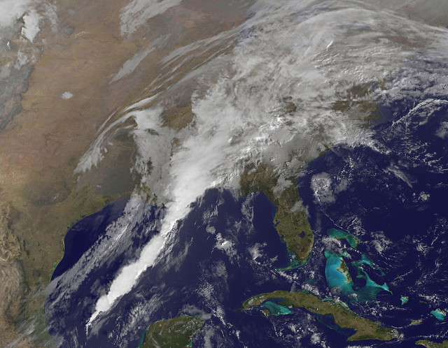
Severe weather is expected to impact the southeastern U.S. today, and the GOES-13 satellite captured an image of a line of clouds associated with the strong cold front that looks like a giant white spike.
This same frontal system brought heavy rain, flooding and tornadoes to Texas yesterday, January 25. Severe weather occurred from San Antonio to Dallas and Fort Worth as the strong cold front pushed through. Dallas reported flooding up to three feet high in some areas. Wind gusts were reported as high as 50 mph.
More severe weather is expected east of the Lone Star State today, January 26, as the line of clouds associated with a strong cold front pushes east. The front is now pushing through Louisiana, Mississippi, Alabama, and western Florida triggering more severe weather warnings and watches.
NOAA's geostationary operational environmental satellite, GOES-13, serves the eastern half of the U.S. providing continuous weather imagery. There is also GOES-15 that covers the western half of the U.S. Both GOES satellites are not only used for weather applications, but also track space weather, oceanographic changes, forest fires and other hazards and provide scientific data collection and information for search and rescue operations. NASA's GOES Project, located at NASA's Goddard Space Flight Center in Greenbelt, Md. creates images and animations from the GOES satellites. The image from today, January 26 was captured at 1331 UTC (8:31 a.m. EST). The line of thunderstorms associated with that cold front looks like a giant solid white spike moving through the southern U.S.
States that may experience severe weather today, January 26, 2012, including tornadoes include Louisiana, Mississippi, Alabama, Georgia and the Florida panhandle. Severe weather is possible today from New Orleans, La. to Jackson, Miss. west to Birmingham, Ala., south to Mobile, Ala. and east to Pensacola, Fla., and into south and central Georgia.
http://www.flickr.com/photos/gsfc/6765664367/in/photostream
 = new reply since forum marked as read
Highlight:
NoneDon't highlight anything
5 newestHighlight 5 most recent replies
= new reply since forum marked as read
Highlight:
NoneDon't highlight anything
5 newestHighlight 5 most recent replies

ProdigalJunkMail
(12,017 posts)for the weather-nerd in all of us...
http://radar.weather.gov/Conus/full_loop.php
sP

dixiegrrrrl
(60,010 posts)We are glued to the radar map on the puter.
No tv, but I can tune in to the local weather online.
Looks like right now, at 2 pm our time, we are clear of the worst of it.
ProdigalJunkMail
(12,017 posts)though i think the nasty stuff will stay mostly to the south...stay safe!
sP
dixiegrrrrl
(60,010 posts)The spring storms really can deserve alertness, as we know.

ThoughtCriminal
(14,047 posts)From up and down, and still somehow,
It's cloud illusions I recall,
I really don't know clouds, at all.
"Both sides now" - Joni Mitchell
Blaze Diem
(3,384 posts)I know all the words to that song. Can't recall when I heard it last though.
Must be an age related memory thing

Fla Dem
(23,656 posts)sce56
(4,828 posts)Was that God responding to Perry droping out of the race?
ProdigalJunkMail
(12,017 posts)Blaze Diem
(3,384 posts)i'm in Dallas
LiberalEsto
(22,845 posts)causing trouble as usual
oldhippie
(3,249 posts)Couldn't they have used some better words? 
dixiegrrrrl
(60,010 posts)
ProdigalJunkMail
(12,017 posts)i guess some people will be offended at even the word 'white'...
sP