Welcome to DU!
The truly grassroots left-of-center political community where regular people, not algorithms, drive the discussions and set the standards.
Join the community:
Create a free account
Support DU (and get rid of ads!):
Become a Star Member
Latest Breaking News
General Discussion
The DU Lounge
All Forums
Issue Forums
Culture Forums
Alliance Forums
Region Forums
Support Forums
Help & Search
General Discussion
Related: Editorials & Other Articles, Issue Forums, Alliance Forums, Region ForumsHurricane Matthew may hit Florida, then make a U-turn and hit again!
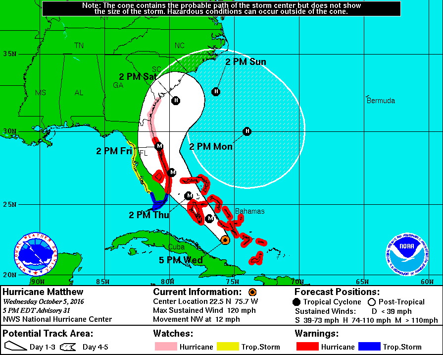
https://robertscribbler.com/2016/10/05/dangerous-hurricane-matthew-strengthening-in-record-hot-environment-may-hit-florida-twice/Look at this storm track, heading back into the Atlantic, and then whipping around to make a second pass on Florida.
 ?w=600&h=480
Hurricane Matthew has already been a storm for the record books. Matthew was the lowest latitude Category 5 storm to form on record in the Atlantic basin. An achievement that bears testament to the amount of heat energy the storm was feeding on — as higher latitude storms can better leverage the Earth’s spin to increase wind speed. It was the longest lasting Category 4-5 storm on record in the Caribbean. And it produced the highest accumulated cyclone energy (ACE) of any hurricane on record for that sea.
(Matthew is predicted to track along the Eastern Seaboard from Central Florida through Georgia as a major hurricane on Friday and Saturday. After this first predicted strike as a major hurricane, long range model guidance is indicating that Matthew could re-curve. Such a path would bring Matthew repeatedly over the near record warm waters of the Gulf Stream and possibly produce a second landfall in Florida by Wednesday of next week. Image source: The National Hurricane Center.)
(Matthew is predicted to track along the Eastern Seaboard from Central Florida through Georgia as a major hurricane on Friday and Saturday. After this first predicted strike as a major hurricane, long range model guidance is indicating that Matthew could re-curve. Such a path would bring Matthew repeatedly over the near record warm waters of the Gulf Stream and possibly produce a second landfall in Florida by Wednesday of next week. Image source: The National Hurricane Center.)
InfoView thread info, including edit history
TrashPut this thread in your Trash Can (My DU » Trash Can)
BookmarkAdd this thread to your Bookmarks (My DU » Bookmarks)
4 replies, 1649 views
ShareGet links to this post and/or share on social media
AlertAlert this post for a rule violation
PowersThere are no powers you can use on this post
EditCannot edit other people's posts
ReplyReply to this post
EditCannot edit other people's posts
Rec (6)
ReplyReply to this post
4 replies
 = new reply since forum marked as read
Highlight:
NoneDon't highlight anything
5 newestHighlight 5 most recent replies
= new reply since forum marked as read
Highlight:
NoneDon't highlight anything
5 newestHighlight 5 most recent replies
= new reply since forum marked as read
Highlight:
NoneDon't highlight anything
5 newestHighlight 5 most recent replies
Hurricane Matthew may hit Florida, then make a U-turn and hit again! (Original Post)
Binkie The Clown
Oct 2016
OP
If Matthew were driving a car, it's like he passed a gruesome accident and wants to come
Baitball Blogger
Oct 2016
#3

pinboy3niner
(53,339 posts)1. The Governor just announced he's putting up 'No U-Turn' signs


Baitball Blogger
(46,750 posts)4. LOL!
Great minds. I should have read your response before posting mine below.

dixiegrrrrl
(60,010 posts)2. We will know more by Sunday
All the interactive weather apps stop on Monday afternoon, 5 days out.
In a couple of days it will show after Monday.
https://www.windyty.com/?2016-10-10-21,34.971,-76.342,5
Baitball Blogger
(46,750 posts)3. If Matthew were driving a car, it's like he passed a gruesome accident and wants to come
back for a second look.