The Big Dark: Weather Service shares satellite image of future rain clouds stretching from China t
Source: Seattle Times
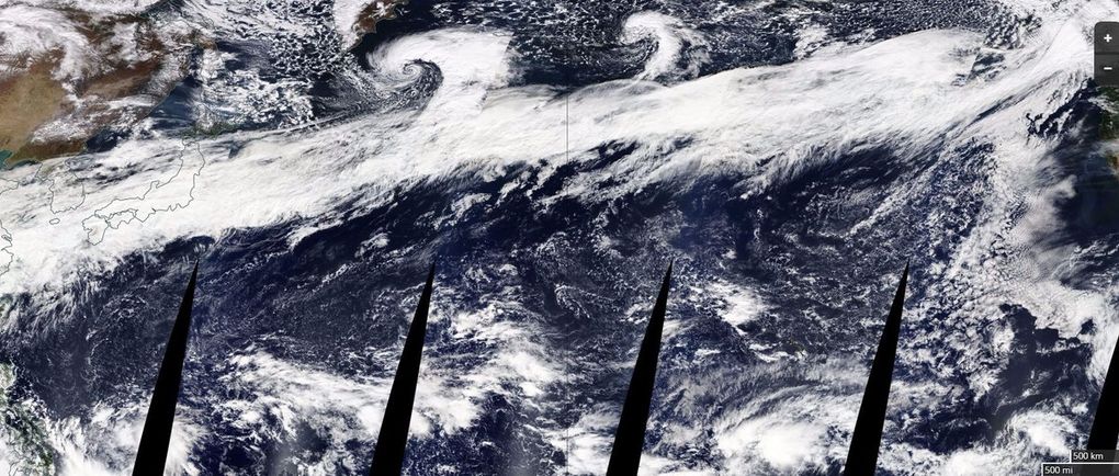
“The Big Dark” is about to begin, as Dustin Guy of the National Weather Service in Seattle likes to describe it.
After a relatively benign first half of the month — with only about a half-inch of precipitation in two weeks — we’re likely to get that much dumped on us on Tuesday alone, he said.
In a satellite image tweeted out by the weather service on Monday, a series of weather systems that basically form “one long stretch of moisture a few thousands miles long that will be hitting us in the face starting tomorrow” can be seen over China and all the way across the ocean to British Columbia.
“That’s our unsettled pattern for us for the foreseeable future,” Guy said.
Read more: https://www.seattletimes.com/seattle-news/weather/the-big-dark-weather-service-shares-satellite-image-of-future-rain-clouds-stretching-from-china-to-puget-sound/
 = new reply since forum marked as read
Highlight:
NoneDon't highlight anything
5 newestHighlight 5 most recent replies
= new reply since forum marked as read
Highlight:
NoneDon't highlight anything
5 newestHighlight 5 most recent replies

FakeNoose
(32,639 posts)This could be a good thing!


wryter2000
(46,045 posts)No more droughts, please.
AngryAmish
(25,704 posts)Hope they get it done.

defacto7
(13,485 posts)They need rain but too much after large fires can cause floods and mud slides. If there hadn't been a burn the ground could possibly handle some extra but non stop rain for long periods will just add to the disaster. They need rain but not that much.

LeftyMom
(49,212 posts)It's not uncommon for high pressure to push storms north into the PNW while leaving most of California dry.
defacto7
(13,485 posts)That long weather pattern was stretching into BC. So it will probably stay to the north.

suffragette
(12,232 posts)Nights should be a little warmer with our cloud blanket back, too.


BlueIdaho
(13,582 posts)Of her displeasure with Trump... 😉
chowder66
(9,068 posts)Amazing.
mountain grammy
(26,620 posts)describes America under trump 