Another Rainy day in the BAY!
Just heard a thunderclap again today..
Flash Flood Watch
the San Francisco Bay Area!
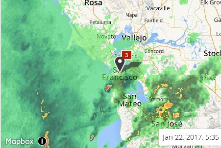
Flash Flood Watch remains in effect for the entire San Francisco Bay Area and Central Coast though Monday evening.
A cold front pushed through the region early Sunday morning brining periods of moderate to heavy rainfall. The area is now in the unstable post frontal environment. Showers and thunderstorms are anticipated to move inland this afternoon before strengthening into this evening. Additional showers and thunderstorms will move through the area tonight and through Monday. This additional rainfall on already saturated soils and full reservoirs will likely lead to flash flooding of area streams and rivers as well as localized urban areas. Mud/rock slides and downed trees should also be expected. Especially during intense bursts of rainfall that occur during thunderstorms.
Flash Flood Watch now in effect through Monday afternoon.
The Flash Flood Watch is now in effect for.
A portion of western California, including the following areas, coastal North Bay including Point Reyes National Seashore, East Bay Hills and the Diablo Range, East Bay interior valleys, Mountains of San Benito County and interior Monterey County including pinnacles National Monument, North Bay interior valleys, North Bay Mountains, northern Monterey Bay, northern Salinas Valley/hollister Valley and Carmel Valley, San Francisco, San Francisco Bay shoreline, San Francisco Peninsula coast, Santa Clara Valley including San Jose, Santa Cruz Mountains, Santa Lucia Mountains and Los Padres National Forest, Southern Monterey Bay and Big Sur coast and Southern Salinas Valley/arroyo Seco and Lake San Antonio.
more..
http://www.google.org/publicalerts/alert?aid=f7a423cec5a58386&hl=en&gl=US&source=wweather
RIGHT NOW
Wind
S 11 mph
Humidity
67%
Dew Point
44°
Pressure
29.67 in
Visibility
8.0 mi
55°
MOSTLY CLOUDY
feels like 52°
H 55° / L 45°
UV Index 1 of 10
RAIN START 1:30pm
Enjoy your day CA!
 = new reply since forum marked as read
