Environment & Energy
Related: About this forumRain Over The High Arctic Ocean: The Third Straight Record Low Arctic Maximum Extent
This past weekend, it rained over the ice of the late winter Kara Sea. Falling liquid drops that whispered of the far-reaching and fundamental changes now occurring at the roof of our world. For an Arctic suffering the slings and arrows of human-forced global warming, the winter ended just as it had begun — with an ice-crushing delivery of warm air from the south.
A burly high pressure system over Russia locked in an atmospheric embrace with a series of low pressure systems stretching from the Barents Sea down into Europe. Winds, originating from the Mediterranean rushed northward between these two opposing weather systems — crossing the Black Sea, the Ukraine, and swirling up over Eastern Europe. The winds wafted warm, above-freezing air over the thawing permafrost of the Yamal Peninsula. And the frontal system they shoved over the melting Arctic sea ice disgorged a volley of anomalous late-winter rain.
As this rain hissed over the ice, delivering a load of heat to its fractured and frail surface, temperatures above the Kara Sea rose to 1 to 2 C — or about 25 to 30 C warmer than average (42 to 54 F warmer than normal). Meanwhile, the frontal boundary lofted by the warm winds rushed on — pushing above-freezing temperatures all the way into the Laptev Sea north of Central Siberia. This most recent rush of warm air to the ice edge region came as a kind of herald for the start of melt season. Melt season start is an event that takes place every year at about this time. But during 2017, the sea ice set to begin this annual melt has never been so weak. The fall and winter warmth has been merciless. Month after month of far warmer than normal temperatures have pounded the ice. And now both sea ice extents and volumes are lower than they have ever been before — or at least since we humans have been keeping track.
Third Consecutive Record Low Sea Ice Extent Maximum
Neven and the sea ice observers over at The Arctic Sea Ice blog produced the following graph depicting what is all-too-likely to be a 2017 in which the sea ice extent maximum just hit another consecutive annual record low:
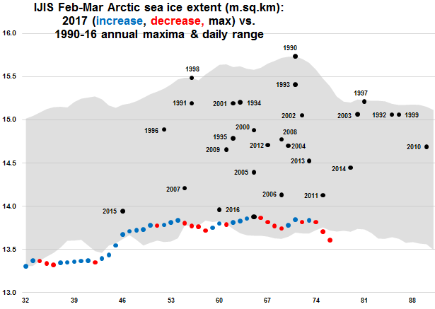 ?w=586&h=416
(2015, 2016 and 2017 were three consecutive record low winter maximum years for sea ice extent in a row. Image by Deeenngee and The Arctic Sea Ice Blog.)
EDIT
Arctic Sea Ice Volume Looks Considerably Worse
Sea ice extent is the measure of how much ocean the ice covers to its furthest-reaching edge. But it’s not the only measure of ice. Volume, which is a measure of both sea ice area and thickness, probably provides a better overall picture of how much ice is left. And the picture of sea ice volume going into the melt season for 2017 isn’t looking very good at all.
 ?w=561&h=429
(Arctic sea ice volume through late February was tracking well below trend. This considerable negative deviation presents considerable risk for record low sea ice measures by the end of 2017 melt season. Image source: PIOMAS.)
EDIT
https://robertscribbler.com/2017/03/20/frailest-ever-winter-sea-ice-facing-a-cruel-cruel-summer/