Environment & Energy
Related: About this forumFor Next 10 Days, Clear Skies, Record Warmth Forecast For Already Shredded Arctic Icepack
A large surface high pressure system has set up shop over the North Pole and is predicted to stay there and intensify over the next ten days. This will bring clear skies, warm temperatures, and near-record and possibly record melting of Arctic sea ice. Over the next ten days, temperatures are predicted to be near or just above freezing over much of the Arctic Ocean--about 2 - 5°C above average--according to the University of Maine’s Climate Reanalyzer.
Arctic sea ice is currently at its second lowest extent on record for this time of year, behind 2016, after the warmest May on record for the Arctic (see Figure 1). The upcoming weather pattern is capable of pushing the sea ice to record-low extent by mid-June.
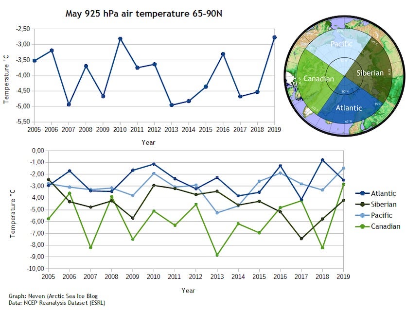
Figure 1. Last month was the warmest May on record for Arctic surface air temperatures between 65°N and 90°N, with an average of -2.77°C beating the previous record of -2.81°C in 2010. The most extreme warmth was in the Pacific and Canadian sectors. Image credit: Neven Curlin/Arctic Sea Ice Forum, data from NOAA Earth System Research Laboratory.
The latest GFS model forecast suggests that the Arctic high will drift to a location a few hundred miles north of Alaska by mid-June and remain strong. This position and strength is characteristic of the Arctic dipole anomaly, which features unusually high pressure over the Arctic Ocean north of North America and unusually low pressure over northeastern Eurasia. This pattern brings in warm southerly winds along the shores of the East Siberian and Chukchi seas, which favors strong ice melt in these sectors and pushes the ice away from the coast, leaving open water. The pressure pattern also causes loss of Arctic sea ice due to winds that transport of ice out of the Arctic Ocean and into the North Atlantic through Fram Strait, to the east of Greenland.

Figure 2. Analyzed surface pressure (black lines) and departure from average pressure in standard deviations (colors) for 6 am EDT Monday, June 5, 2019, from the 6Z Monday run of the GFS-fv3 model. An unusually strong 1030 mb high pressure system was centered over the North Pole (center of image). The orange colors showed that this high was up to 2 standards deviations stronger than average. Image credit: tropicaltidbits.com.
The Arctic dipole anomaly was very well developed throughout the summer of 2007 and was in part responsible for the very low September ice extent recorded that year (the second lowest in the satellite record). If the Arctic dipole anomaly becomes established this month and persists through much of the summer, 2019 could easily challenge 2012 for unfortunate distinction of having the lowest Arctic sea ice extent on record.
According to an email from Dr. Mark Serreze, director of NOAA's National Snow and Ice Data Center, "It's been a very warm spring and Arctic sea ice extent is already well below average. The sea level pressure pattern for May is reminiscent of what we saw during the summer of 2007 which led to the (then) record low September ice extent. This pattern is expected to last through mid-June. Will it continue to persist through the bulk of the summer melting season? We'll have to wait and see."
EDIT
https://www.wunderground.com/cat6/Strong-Arctic-High-Pressure-System-Bringing-Significant-Melting-Sea-Ice?cm_ven=cat6-widget
 = new reply since forum marked as read
Highlight:
NoneDon't highlight anything
5 newestHighlight 5 most recent replies
= new reply since forum marked as read
Highlight:
NoneDon't highlight anything
5 newestHighlight 5 most recent replies

rampartc
(5,407 posts)
flotsam
(3,268 posts)you may be a New Englander...