Scientists Want to Make a 3D Map of the Entire World Before Climate Change Ruins It
By Brandon Specktor 9 hours ago Science & Astronomy
To record the world's most vulnerable places before they disappear, we're going to need a lot of lasers.
In 2018, archaeologists bathed part of a Guatemalan forest in laser beams to reveal the profile of
a hidden, ancient metropolis. Now, researchers at a nonprofit called The Earth Archive would like
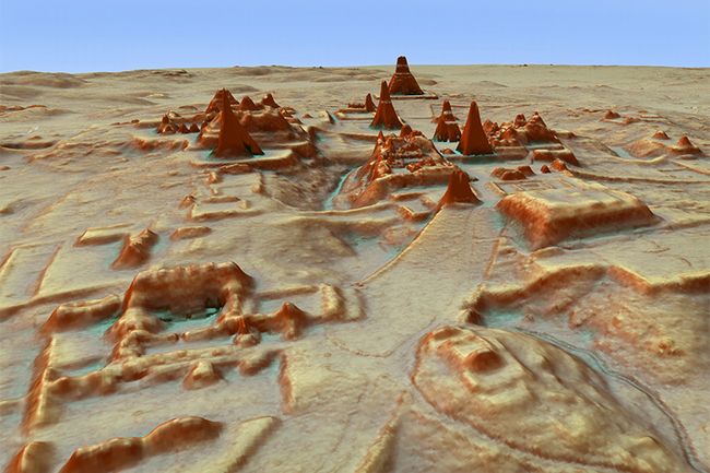
to use this method again to map the entire land area of the Earth.(Image: © Image courtesy of
Luke Auld-Thomas and Marcello A. Canuto)
Earth is changing faster than anyone can comprehend. Every day, more forests burn, more glaciers melt and more evidence of the world's ancient cultures slips away. Change of some kind is, of course, inevitable — but it is happening more quickly and more severely because of the effects of human-caused climate change. And that has some scientists worried: The quicker Earth changes,the less time there is to learn from its past and understand its mysteries.
Recently, two researchers proposed a way to preserve a record of our planet in its present state: use lasers to create a high-resolution, 3D map of the entire world. It's now the mission of a new nonprofit project called The Earth Archive, which is spearheaded by archaeologist Chris Fisher and geographer Steve Leisz, both of Colorado State University.
"The climate crisis threatens to destroy our cultural and ecological patrimony within decades," Fisher said earlier this year in a TEDx talk. "How can we document everything before it's too late?"
The answer, Fisher said, is light detection and ranging, or lidar — a method of remote scanning that uses aircraft to shower a landscape with a dense net of laser beams. From this bombardment of light, researchers can create high-resolution, 3D maps of a given area and then digitally edit out foliage and other features that might be concealing hard-to-spot secrets near Earth's surface.
More:
https://www.space.com/map-the-earth-with-lasers.html