Weather Watchers
Related: About this forumGaylord, MI Tornado rated an EF-3 with winds of 150 mph.
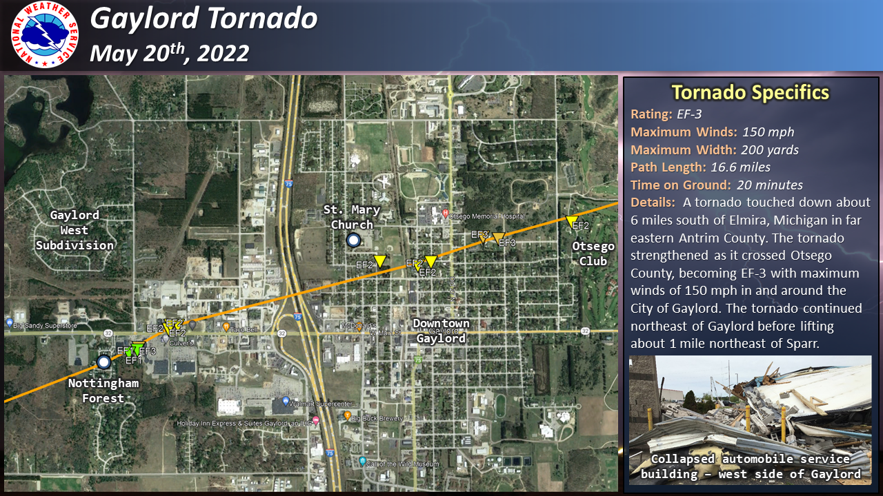
From the NWS Gaylord:
Gaylord, MI
Weather Forecast Office
Recap of Severe Weather: May 20th, 2022
Multiple thunderstorms tracked across northern Michigan during the afternoon, including a supercell thunderstorm that produced the tornado that hit the town of Gaylord along with very large hail in other parts of the area.
Setting the stage for severe weather was a trough that rotated across the upper Midwest that developed and strengthened surface low pressure west of Lake Michigan. This system helped draw a warm, moist airmass northward across the state that helped provide the instability necessary to support severe thunderstorms later in the day. Storms initially formed along the cold front across Wisconsin during the morning hours and moved northeast across Lake Michigan, making it into the forecast area by early afternoon. The strongest line segment generated a measured wind gust of 76 mph at Frankfort Light and continued to produce damaging wind gusts across Leelanau and Antrim counties as it quickly moved northeast.
As this segment moved further away from the cold front, it began to transition into a supercell thunderstorm. This storm moved east-northeast across a very favorable environment in place across northern lower Michigan, eventually producing a tornado that caused considerable damage in the city of Gaylord. This supercell continued to trek across the area, producing baseball-sized hail in Posen.
A special weather balloon launch was conducted at 3 PM EDT to get a better look at the environment in place ahead of the approaching storm. The data from this balloon launch displayed a rare environment in place that was supportive of storms producing damaging wind gusts, very large hail, and tornadoes. Specifically, the data showed ample instability in place. This is measured by a variable called Convective Available Potential Energy (CAPE), where values were near 2,000 Joules/kilogram. Very strong wind shear was also in place, which is a measure of the change in wind speed and direction with height in the atmosphere. Almost 60 knots of shear was measured from the surface to 6 km above ground level. Storm-relative helicity (SRH), a variable that shows the tendency of the air being drawn into the storm to spin, had values of almost 300 meters^2/second^2. The magnitude of all of these variables are very high, supportive for supercell thunderstorm development and severe weather. Additionally, it is very rare for this magnitude of all of these variables to come together at once across northern Michigan.
 [/img
[/img
https://www.weather.gov/apx/severe-2022May20
This is what an EF-3 tornado can do to a mobile home:

 = new reply since forum marked as read
Highlight:
NoneDon't highlight anything
5 newestHighlight 5 most recent replies
= new reply since forum marked as read
Highlight:
NoneDon't highlight anything
5 newestHighlight 5 most recent replies

Starseer
(72 posts)I grew up in North Texas where supercells were a feature of every month from March to August, and EF-2 and higher-rated tornadoes were both expected and prepared for each and every year, whether or not they actually occurred.
I've now lived in Northern Michigan for over 15 years and have occasionally held public talks about weather. It is not an exaggeration to say that an EF-3 tornado that also strikes a (relatively-densely) populated area anywhere north of M-72 is generally outside the experiences of any person that lives here year-round. "Historic" will be a word used to describe the Gaylord tornado in the future. It is only by sheer luck that (at least at the current time) only two have been reported as losing their lives, and only 44 were injured.
This is the strongest tornado to occur in the state since the Dexter tornado of March 15, 2012.
Numerous vehicles were overturned on the west side of I-75 in the commercial district, particularly at the Culver's on the south side of M-32 and near the Marathon station on the north side of M-32. Maurice's (in Pine Ridge Square near the Culver's) took a direct hit. The Goodwill on the north side of M-32 sustained heavy damage. Panera, Aldi's, and Little Caesar's are temporarily closed. Much of the Nottingham Forest Mobile Home Park (WSW of Pine Ridge Square) was destroyed.
On the east side of I-75, the tornado passed through the northern side of the downtown area; the residential areas to the east and to the north sustained some damage (a few of which were complete failures of stick-built homes consistent with an EF-3) but most escaped major damage. It was a very fortunate happenstance that the tornado passed just S and E of Otsego Memorial Hospital. For a time, OMH had to be in diversion status, but is now back to accepting patients.
For the residents of Gaylord, this is an event that won't soon be forgotten.

catbyte
(34,447 posts)We moved up there in 1959 when I was 4 from Montcalm County to be closer to my mom and dad's family. Our house was seriously damaged by the EF-4 tornado that ripped through the area in April 1956, so I lived through a nasty one but don't remember it. Or maybe I do somewhere in my subconscious because I've had a fascination with storms, well, the weather in general, for as long as I can remember. Interestingly, most of the strongest tornadoes to hit the state happened in the U.P. coming in from Wisconsin. Lake Michigan tends to moderate the weather here in the lower, but obviously not on Friday.
I live in Lansing now, so welcome to DU, fellow Michigander. You might not be a native, but you're a Michigander now. If you live in Trump Country, good luck, lol. We called some areas (Antrim County, ahem) Michissippi.
Again, welcome! 