Latest Breaking News
In reply to the discussion: Mali Islamist militants 'destroy' Timbuktu saint's tomb [View all]happyslug
(14,779 posts)From Carthage to Timbuktu, is the quickest way to travel between the Niger River Valley and the Mediterranean Sea. The Niger is the 11th longest river in the world
http://www.socialstudiesforkids.com/articles/geography/nigerriver.htm
http://en.wikipedia.org/wiki/Niger_River
http://www.fao.org/docrep/W4347E/w4347e0i.htm
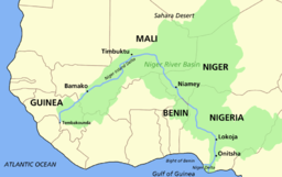
Notice where Timbuktu is on the Niger, It is at the point where the NIGER River is the closet to the Mediterranean Sea, it is also a short walk to the Volta River system and the Senegal River Systems (The other two main trade routes in West Africa).
A tributary flows in the direction of Carthage from Timbuktu, but it is a non-navigable tributary, but once at Timbuktu, you can get a boat and float downstream to Nigeria, or sail upstream to Guinea (and then a short walk to the Senegal River). And it is a relatively short walk to anywhere else on the "Gold Coast" of Africa (Short walks to the Volta River system). Gold was produced on the Gold Coast (and later slaves) and Ivory. Europe traded salt, plentiful in Tunisia (and later Spain) for gold and Ivory and later slaves.
Remember, this route started as a HORSE wagon route, later converted to Camels as the Sahara dried out, thus following a river was preferred even if it was dried out most of the time.
Furthermore, movement south of Algeria and Morocco, had to go over the Atlas mountains, thus avoided if possible,
More on the Atlas Mountains:
http://en.wikipedia.org/wiki/Atlas_Mountains
Going south from Tripoli Libya in the direction of Timbuktu was prevented by the Tibesti Mountains, while no where at high as the Atlas Mountains, it is some of the dryest areas on the planet. People avoid it if at all possible. The only place worse is the Quttara Depression just inside Egypt on the Libyan-Egyptian Border. No body lives there (140 degrees in the shade, and they isn't any).
More on the Tibesti Mountains.
http://en.wikipedia.org/wiki/Tibesti_Mountains
More on the Qattara Depression
http://en.wikipedia.org/wiki/Qattara_Depression
In Southern Tunisian has a gap between these two sets of mountains, that is watered by the Atlas Mountains. Thus you have Lake Chott el Djerid. It is dry in the Summer, but a salt lake in the Winter, thus you have some fresh water in the area reaching the lake in winter.
http://en.wikipedia.org/wiki/Chott_el_Djerid
Thus the trade route was from Carthage into the middle of what is now Eastern Algeria (Avoiding the Atlas Mountains). then south to Timbuktu (Avoiding the Tibesti Mountains of Southern Libya and Northern Chad). It is the best LAND ROUTE between the Mediterranean and the Niger River Valley, thus was used for centuries, until a sea route was found by the Portuguese in the 1400s.
Please note the reason Ships did NOT go south of Morocco prior to the 1400s was the Equator is in Morocco, thus south of Morocco you lost the North Star. Sailors had used the North Star for thousands of years and did NOT want to sail anywhere where it was "gone" for then they had no reference point to determine where they were. Henry the Navigator, a Prince of Portugal kept sending ships south. Sailors would go a little bit further south each time, given the previous trip had come back (This is the start of the use of widespread use of the Compass). Finally one ship turned the corner and sailed into the Gold Coast, and brought back a fortune. By the death of Henry, Portugal had started to mint vast quantities of gold coins do to its new wealth.
Henry the Navigator was the Head of the "Order of Christ", a group formed when the Pope dissolved the Knights Templar. Technically all of the Assets (and Knights) of the Templars were to go to the Hospitaliars, but the Kings of Spain and Portugal opposed that, thus formed a new order from the Templars located in Spain and Portugal. Thus the wealth of the Templars paid for Henry's expeditions around Africa.
http://en.wikipedia.org/wiki/Henry_the_Navigator
Just a note on why the trade route went the way it did, and why it lasted so long (No way to tell North or South without being able to see the North Star, thus the land route was the only possible way till the invention of the compass) and died so quickly (Compass and sea trade was more efficient).
Side note: There is a report of an Egyptian trip around Africa, but it lead to nothing:
http://www.touregypt.net/featurestories/nechoafrica.htm
Edit history
 = new reply since forum marked as read
Highlight:
NoneDon't highlight anything
5 newestHighlight 5 most recent replies
RecommendedHighlight replies with 5 or more recommendations
= new reply since forum marked as read
Highlight:
NoneDon't highlight anything
5 newestHighlight 5 most recent replies
RecommendedHighlight replies with 5 or more recommendations