Welcome to DU! The truly grassroots left-of-center political community where regular people, not algorithms, drive the discussions and set the standards. Join the community: Create a free account Support DU (and get rid of ads!): Become a Star Member Latest Breaking News General Discussion The DU Lounge All Forums Issue Forums Culture Forums Alliance Forums Region Forums Support Forums Help & Search

BumRushDaShow

(128,979 posts)
20. The traditional "blue" counties in upstate PA
Tue Nov 29, 2016, 08:32 PM
Nov 2016

Central PA (Dauphin County where Harrisburg is), SW PA (Allegheny County), and even Erie (city and Erie County in NE PA) were far too close compared to past elections and in the case of Erie, Trump won it according to the state results.

If you look at the last time PA went for a Republican President in the map below (1988), you can see which counties were more reliably Democratic (basically the more populated counties in the state - the blue highlighted one in the NE part of the state is where Scranton is - Lackawanna County) -


https://www.google.com/?gws_rd=ssl#q=pa+general+election+1988

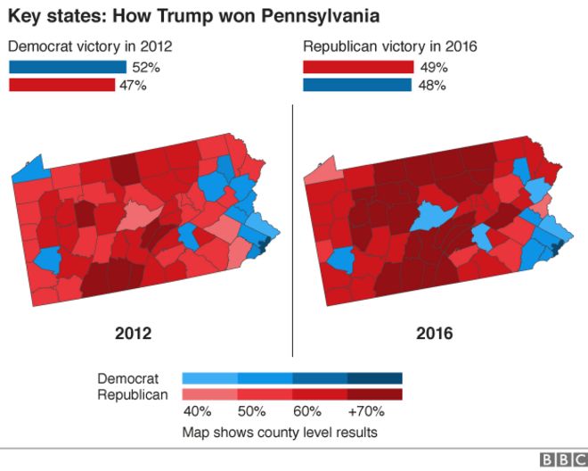
BBC had an interesting county comparison map!


Ironically, when people talk about the Pennsyltucky "T", you see it in that 2016 map! But what people still forget is that most of those "dark red" counties have minuscule populations - some literally have the same population as a single neighborhood in Philadelphia. The fact that Hillary won Chester County was interesting to see as the "blue persuasion" further spreads westward away from the city (something counter-intuitive to the argument about "concentration" of political beliefs in urban areas only).

Latest Discussions»Latest Breaking News»Montgomery County, Pa., B...»Reply #20